
| Method | Copper engraved |
| Artist | Hondius, Jodocus the Younger |
| Published | [Johannes et Cornelis Blaeu, Amsterdam, 1639] |
| Dimensions | 95 x 132 mm |
| Notes |
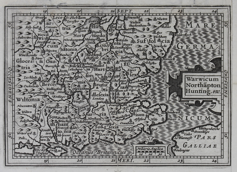
A miniature map of south east England, encompassing the counties of Kent, Surrey, Sussex, Hampshire, the Isle of Wight, Wiltshire, Berkshire, Gloucestershire, Oxfordshire, Warwickshire, Northamptonshire, Huntingdonshire, Cambridgeshire, Suffolk, Essex, Buckinghamshire, Bedfordshire, Hertfordshire, and Middlesex, originally engraved by Jodocus Hondius the Younger for the 1616 printing of Bertius' Tabularum Geographicarum Contractarum. The map, a reduction of the Atlas Minor map of the same region, was part of a suite of maps intended to replace and update an earlier series of miniature maps engraved by Hondius' uncle, Pieter van den Keere. This particular example, with blank verso, was issued in 1639 by Johannes and Cornelis Blaeu in their second edition of Regner Vitellius abridged version of Camden's Britannia. Jodocus Hondius the Younger (1594-1629) was a Dutch Flemish cartographer, engraver, and publisher, and the son of the famous geographer Jodocus Hondius the Elder. With his brother, Henricus, and his mother Coletta, the sister of Pieter van den Keere, Jodocus took over the family printing business upon the death of his father in 1612. Although not as prolific an engraver as his father or brother, Jodocus still produced an impressive oeuvre of cartographic works. Chief amongst them are a series of over 200 miniature maps he engraved in 1616 for later editions of Bertius' Tabularum Geographicarum Contractarum. It seems that Jodocus and his brother Henricus fell out over the running of the family business, and upon his death in 1629, his own plates were sold to Willem Blaeu, the family's key competitor. Pieter van den Keere, also known frequently as Petrus Kaerius, came to England in 1584, as a Protestant refugee from his home town of Ghent with his sister Colette, who married Jodocus Hondius, in 1587. It was probably from Hondius that Keere learned to engrave. Both engravers left London in 1593 to settle in Amsterdam. His first set of miniature maps were produced for the Middelburg publisher Cornelis Claesz, for inclusion in Barent Langenes' Caert Thresoor. Keere began to engrave a series of miniature maps in 1599 in preparation for a small atlas of the British Isles. The maps were first published in 1617 by William Blaeu with plate numbers and Latin text. They then passed to George Humble, who published them in 1619 and then again in 1627, by which time they had become known colloquially as 'Miniature Speeds.' Petrus Bertius (14th November 1565 – 13th October 1629) was a Flemish theologian, historian, geographer and cartographer and was related to Jodocus Hondius Sr. and Pieter van den Keere by marriage. Bertius studied at the University of Leiden and later traveled in Germany and Russia. In 1620 he emigrated to France where he was appointed as a cosmographer to the court Louis XIII. Bertius published a number of folio maps, but never published an atlas of his own. His maps were either separately published or included in atlases and books by other publishers. The Blaeu family were one of the most famous publishers of maps, globes and atlases during the seventeenth-century. Cartographers, globe makers and booksellers, the Blaeu business flourished in Amsterdam for over 40 years, until a fire destroyed their premises in 1672. They lost all of their plates, prints and stock, which effectively ruined the firm. Willem Blaeu founded the business in 1596. It initially functioned as a globe and instrument makers, but soon expanded into maps, topography and sea charts. The Atlas Novus was Willems great work; a major work which intended to include the most up-to-date maps of the entire world. He issued the first two volumes in 1635, but died in 1638 before the atlas was completed. The running of the business was passed on to his sons Johannes and Cornelius, in addition to the role of the official cartographer of the East India Company. After the death of Cornelis in 1644, Johannes continued the business alone and established his own reputation as a great mapmaker. Johannes completed his father's grand project in 1655 with the sixth and final volume of the Atlas Novus. He also produced the Tooneel der Steden van der Vereenighde Nederlanden in 1649-1653, as well as a similar set of Italian town plans which were published in 1663. Condition: Central vertical fold as issued. Trimmed to border along right margin, as issued, now remargined. Tears to top margin, with old adhesive tape repairs. Blank on verso. |
| Framing | unmounted |
| Price | £95.00 |
| Stock ID | 49103 |