
| Method | Copper engraved with hand colour |
| Artist | Jansson, Jan |
| Published | [Amsterdam, c.1640] |
| Dimensions | 385 x 502 mm |
| Notes |
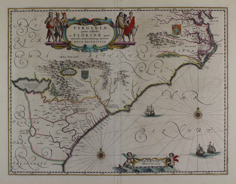
A large and decorative map of the historic territories of Virginia and Florida, covering the modern day American States of Virginia, the Carolinas, and Georgia, from a German edition of Jansson's Atlas Novus. The map, practically identical to that of Blaeu, pays particular attention to the claims of the French and British to the various territories of the eastern coast, with the Royal Crests of both superimposed. The region around Chesapeake Bay, following John Smith's explorations, is shown in some detail, with the territory of the famous Powhatan marked. Inland, in the region of the modern Carolinas, are two fictional lakes. The map is further embellished by a pair of decorative cartouches, one containing the title flanked by figures in Native American dress, and the scale in German miles held aloft by a pair of baby tritons. Johannes Janssonius (1588 - 1664) was a famed cartographer and print publisher. More commonly known as Jan Jansson, he was born in Arnhem where his father, Jan Janszoon the Elder, was a bookseller and publisher. In 1612 he married the daughter of the cartographer and publisher Jodocus Hondius, and then set up in business in Amsterdam as a book publisher. In 1616 he published his first maps of France and Italy and from then onwards, produced a very large number of maps which went some way to rival those of the Blaeu family, who held a virtual monopoly over the industry. From about 1630 to 1638 he was in partnership with his brother-in-law, Henricus Hondius, issuing further editions of the Mercator/Hondius atlases to which his name was added. On the death of Hondius he took over the business, expanding the atlas still further, until eventually he published an eleven volume Atlas Major on a scale similar to Johannes Blaeu's magnum opus. After Jansson's death, his heirs published a number of maps in the Atlas Contractus of 1666, and, later still, many of the plates of his British maps were acquired by Pieter Schenk and Gerard Valck, who published them again in 1683 as separate maps. Condition: Central vertical fold, as issued. Minor repaired tears to margins. Old tabs of framers tape to top and bottom of central fold. German text on verso. |
| Framing | unmounted |
| Price | £1,000.00 |
| Stock ID | 48620 |