
| Method | Copper engraved with early hand colour |
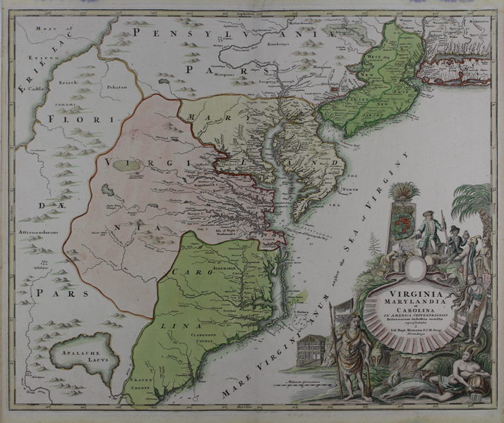
| Artist | Homann, Johann Baptist |
| Published | repraesentatae a Ioh. Bapt. Homann S.C.M. Geog. Norimbergae [Nuremberg, c.1720] |
| Dimensions | 490 x 582 mm |
| Notes |
A superb and highly decorative early eighteenth century map of the eastern coast of the United States, with a particular focus on Virginia, Maryland, and the Carolinas, from the Maior Atlas Superiore. The map is ornamented in full wash colour, and features a very large title cartouche illustrating trade between the British and various First Nations people, as well as symbols of agriculture, industry, and prosperity. To the north, New Jersey is shown divided into East and West, and Florida stretches north all the way up to the borders of Lake Erie. Johann Baptist Homann (20th March 1664 - 1st July 1724) was a German engraver and cartographer, and the Imperial Geographer to the Holy Roman Emperor Charles VI. In 1702 he opened a publishing house in Nuremberg, and his maps often make reference to his membership of the Prussian Royal Academy of Sciences and his imperial patronage. Upon his death, his maps passed to the Homann Heirs company and reprinted many times before the company closed in 1848. Condition: Central vertical fold, as issued. Old ink staining and waterstains to margins, not affecting map. Blank on verso. |
| Framing | unmounted |
| Price | £2,000.00 |
| Stock ID | 48621 |