
| Method | Steel engraved with original hand colour |
| Artist | Rapkin, John |
| Published | John Tallis & Company, London & New York. The Illustrations by H. Warren & Engraved by J. Rogers. The Map Drawn & Engraved by J. Rapkin. [c.1850] |
| Dimensions | 350 x 250 mm |
| Notes |
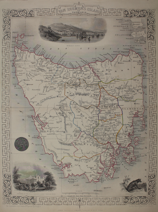
A decorative map of the Australian state of Tasmania, formerly known as Van Diemen's Land, from Tallis' Illustrated Atlas. The island is divided into its 'counties,' a system which has since been superceded by the present Lands Administrative Divisions, with borders outlined in hand colour. The map is surrounded with vignettes showing a prospect of Hobart, the Residence of the Van Dieman's Land Company's Agent at Highfield, and an extinct Thylacine (Tasmanian Tiger). John Tallis was a British publisher and one of the most popular cartographers of the 19th Century. Tallis maps were highly valued for their accuracy, but perhaps more so for their charming vignettes and ornamentation. Engraved by John Rapkin, these maps were praised by the New York Sun as "the most accurate and most splendid publication of the kind ever issued". The Bristol Times observed that Mr. Tallis maps "are not only critically correct, but are accompanied with elegant and appropriate engravings illustrative of the manners and costumes of the different countries." John Rapkin was an engraver and mapmaker active in Britain in the mid-nineteenth century. He drew and engraved the maps for John Tallis' 'The Illustrated Atlas and Modern History of the World' (1845-51), which was later re-issued by the London Printing and Publishing Company. He also drew and engraved maps for R. Montgomery Martin's 'British Colonies, their history' (1849), and Wright's 'Universal Pronouncing Dictionary' (c.1850). Condition: Central horizontal folds, as issued. Time toning to edges of sheet. Blank on verso. |
| Framing | unmounted |
| Price | £150.00 |
| Stock ID | 48731 |