
| Method | Copper engraved with hand colour |
| Artist | Porro, Girolamo after Magini, Giovanni Antonio |
| Published | [Paolo & Francesco Galignani, Padua, 1598] |
| Dimensions | 130 x 175 mm |
| Notes |
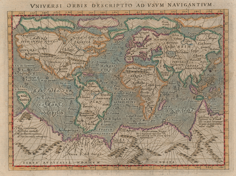
A map of the world, with particular reference to navigation, from 'Geografia cioe Descrittione Universale della Terra Partita' the first Italian translation of Giovanni Antonio Magini's edition of Claudius Ptolemy's Geographia. The map is effectively a Mercator projection, one of two that Porro produced concurrently. Where this example has the prime meridian at the Azores, the other, for editions of Tommaso Porcacchi's 'L'isole più famose del mondo,' has the prime meridian at the Straits of Gibraltar. The present example retains Mercator's four Arctic islands along the top border, with Anian and Quivera clearly marked in North America. South America is very squat, West Africa is significantly elongated, and the massive supercontinent of Terra Incognita takes up the entire southern edge of the map, with Porro adding mountain ranges for effect. The entire map is criss-crossed by numerous rhumb-lines. Girolamo Porro (c.1520-1604) was an Italian engraver active in Venice and his native Padua, working predominantly as a map engraver for Tommaso Porcacchi, and Girolamo Ruscelli. Giovanni Antonio Magini (1555-1615) was an Italian scientist, cartographer, and chair of mathematics at the University of Bologna. A prominent geocentrist, he was a correspondent of many notable contemporaries, including Tycho Brahe, Kepler, and Ortelius. His commentary on Ptolemy's Geographia, with accompanying copperplate maps by Porro, appeared in Latin in its first edition in 1596, with the first Italian translation by Leonardo Cernoti printed in 1598. Condition: Time toning and damp stains to edges of sheet. Italian text above, below, and on verso. |
| Framing | framed |
| Price | £700.00 |
| Stock ID | 51940 |