
| Method | Copper engraved with hand colour |
| Artist | Ortelius, Abraham |
| Published | Cum Imp. & Regiae Mt. Privilegio [Antwerp, 1595] |
| Dimensions | 345 x 502 mm |
| Notes |
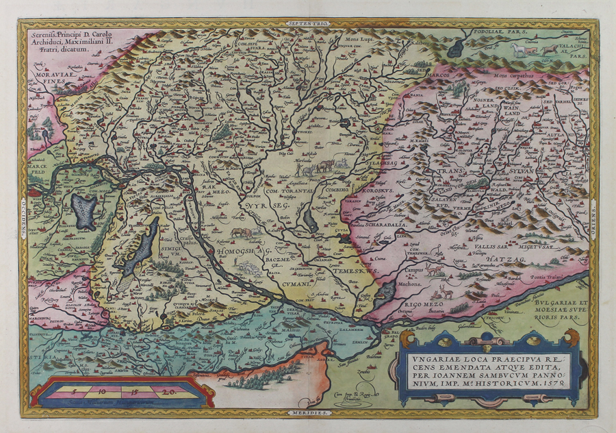
A beautiful sixteenth century map of Hungaria, from the 1595 Latin edition of Ortelius' famous Theatrum Orbis Terrarum. The map encompasses the whole of modern day Hungary, as well as parts of Austria, Czech Republic, Slovakia, Romania, Serbia, and Croatia, ornamented in full hand colour. Rivers, mountains, forests, and lakes are shown pictorially, and the title is enclosed in a decorative strapwork cartouche at bottom right, crediting the map to Ortelius' friend and colleague János Zsámboky (Johannes Sambucus), a Hungarian humanist scholar who was the court physician of Holy Roman Emperor Maximillian II. Abraham Ortelius (1527 -1598) was a Flemish cartographer, cosmographer, geographer and publisher and a contemporary of Gerard Mercator, with whom he travelled through Italy and France. Although it is Mercator who first used the word "Atlas" as a name for a collection of maps, it is Ortelius who is remembered as the creator of the first modern atlas. Theatrum Orbis Terrarum was the first systematically collated set of maps by different map makers in a uniform format. Three Latin editions as well as a Dutch, French and German edition of Theatrum Orbis Terrarum were published by 1572 and a further 25 editions printed before Ortelius' death in 1598. Several more were subsequently printed until around 1612. Ortelius is said to have been the first person to pose the question of the continents once being a single land mass before separating into their current positions. Ex.Col.: László Gróf Condition: Strong dark impression with full margins. Central vertical fold as issued. Minor time toning to margins. Latin letterpress text on verso. |
| Framing | unmounted |
| Price | £600.00 |
| Stock ID | 51020 |