
| Method | Copper engraved |
| Artist | Kircher, Athanasius |
| Published | [Amstelodami, Apud Joannem Janssonium & Elizeum Weyerstraten, Anno MDCLXV Cum Privilegiis [1665]] |
| Dimensions | 365 x 335 mm |
| Notes |
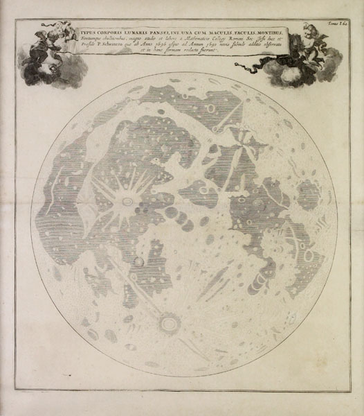
Athanasius Kircher's rare and historically significant map of the near side of the moon, from his geographical masterwork Mundus subterraneus, quo universae denique naturae divitiae. The map is remarkably impressive considering its seventeenth century origin, clearly showing features of the moon's surface that are still recognisable today, including the Ocean of Storms, the Seas of Tranquility, Fecundity, and Rain, as well as the larger craters Kepler, Copernicus, Langrenus, and Tycho. The lengthy title is enclosed in a title ribbon, held aloft by a pair of putti. Athanasius Kircher (1602-1680) was one of the leading lights of the seventeenth century's European academic community. A German Jesuit, Kircher's interests were many and varied, including comparative theology, geology, biology, history, philology, philosophy, ethnography (particularly Sinology and Egyptology), medicine, law, and technology. His studies championed empiricism, even to the point where, when in Italy, he was lowered into an active volcano. His most celebrated works included the Mundus Subterraneus, a treatise on the actions and interactions of fire, water, and air in natural phenomena and one of the earliest works of volcanology, as well as pamphlets on magnetism, Egyptian heiroglyphics, and the Tower of Babel. Johannes Janssonius (1588 - 1664) was a famed cartographer and print publisher. More commonly known as Jan Jansson, he was born in Arnhem where his father, Jan Janszoon the Elder, was a bookseller and publisher. In 1612 he married the daughter of the cartographer and publisher Jodocus Hondius, and then set up in business in Amsterdam as a book publisher. In 1616 he published his first maps of France and Italy and from then onwards, produced a very large number of maps which went some way to rival those of the Blaeu family, who held a virtual monopoly over the industry. From about 1630 to 1638 he was in partnership with his brother-in-law, Henricus Hondius, issuing further editions of the Mercator/Hondius atlases to which his name was added. On the death of Hondius he took over the business, expanding the atlas still further, until eventually he published an eleven volume Atlas Major on a scale similar to Johannes Blaeu's magnum opus. After Jansson's death, his heirs published a number of maps in the Atlas Contractus of 1666, and, later still, many of the plates of his British maps were acquired by Pieter Schenk and Gerard Valck, who published them again in 1683 as separate maps. Condition: Central horizontal fold, as issued. Repair to margin. Minor time toning to margins. Framed in a black box frame. |
| Framing | framed |
| Price | £1,500.00 |
| Stock ID | 48144 |