
| Method | Copper engraved with hand colour |
| Artist | Homann Heirs |
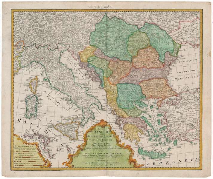
| Published | ab Augusto Gottlob Boehmio Electoris Saxoniae Cohortis Architecton: Milit: Mathematico et Societatis Cosmographiae Sodali. Norimbergae, Cura Homannianorum Heredum. C.P.S.C.M. Ao. 1766 [Nuremberg, 1766] |
| Dimensions | 470 x 552 mm |
| Notes |
A large and impressive late-eighteenth century map of the course of the Danube, with a particular focus on the Balkans and the Grecian archipelago, published by the Homann Heirs for the Maior Atlas Superiore following the cartography of August Gottlob Böhme. The Balkans and Greece are presented in full hand colour, and principal cities are picked out in red. Adjoining parts of Germany, Italy, Turkey, Sicily, Corsica, Sardinia, France, and North Africa are outlined in hand colour. At bottom centre, the lengthy title is enclosed in a baroque framed cartouche, as is a mile scale in the bottom left corner. A superscript title in French reads: 'Cours de Danube. ' Johann Baptist Homann (20th March 1664 - 1st July 1724) was a German engraver and cartographer, and the Imperial Geographer to the Holy Roman Emperor Charles VI. In 1702 he opened a publishing house in Nuremberg, and his maps often make reference to his membership of the Prussian Royal Academy of Sciences and his imperial patronage. Upon his death, his maps passed to the Homann Heirs company and reprinted many times before the company closed in 1848. August Gottlob Böhme (1719-1797) was a German cartographer and mathematician. Condition: Central vertical fold, as issued. Minor time toning and staining to margins, not affecting map. Blank on verso. |
| Framing | unmounted |
| Price | £400.00 |
| Stock ID | 51679 |