
| Method | Copper engraved |
| Artist | Collins, Greenvile |
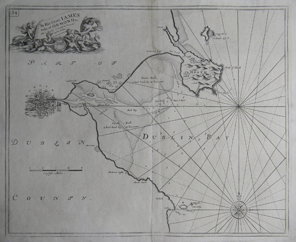
| Published | 1693 |
| Dimensions | 445 x 560 mm |
| Notes |
Captain Greenvile Collins was one of the most important English mapmakers yet little is known about the man himself. He was an officer in the Royal Navy and served with Sir John Narborough in his expedition to the Straits of Magellan, and subsequently served against Algerian pirates. He was made a commander in 1679 and Charles II granted him the title "Hydrographer to the King". It was also Charles II who, in 1681, II appointed Collins to undertake a "survey of the seacoasts of the Kingdom by measuring all the Sea coasts with a chain and taking all the bearings of the headlands". From 1681 to 1688 Collins was engaged in making this survey, during the course of which he produced some 120 manuscript draughts. Commencing in about 1685 or 1686, the task of engraving the more important of these began, with the maps apparently available separately as they were completed. By 1693 the engraving was complete and the charts were published in atlas form, entitled Great Britain's Coasting Pilot. This sea-atlas contained 47 charts of the British coast, and proved a great commercial success, although there were criticisms of its accuracy in some quarters. Collins' atlas was much needed as, until its publication, British mariners sailing in British waters had been dependent on the earlier sea-charts of the Dutch. With both charts and sailing directions, Collins' atlas filled a gap in the market, especially when considering the political climate of the day and the Anglo-Dutch Wars of the latter seventeenth century. As a consequence of its popularity, the atlas was re-issued by the firm of Mount and Page throughout the next century with the addition of some new and up-dated charts. The original plates, which may have been engraved by Herman Moll, are distinctively engraved, often with distinctive title cartouches, and are usually found on thick paper. For most of this time, the Coasting Pilot was the best available sea-atlas of British waters, although the publishers did little to up-date or improve the delineations. |
| Framing | unmounted |
| Price | £550.00 |
| Stock ID | 22045 |