
| Method | Copper engraved with hand colour |
| Artist | Browne, Joseph |
| Published | Joseph Browne Sculpsit 1682 [Oxford, 1686] |
| Dimensions | 640 x 540 mm |
| Notes |
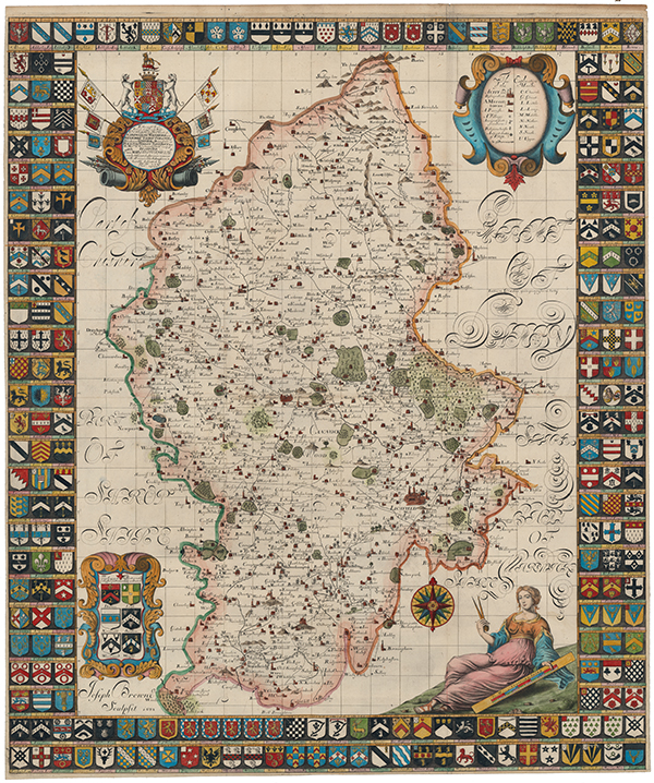
Full title reads: 'To the most Honble. Potent and truely Noble Charles Talbot, Earle of Shrewsbury, Waterford and Wexford, Ld. Talbot Strange of Blackmere Gifford of Brimsfield, Furnival Verdon Lovetoft &c. His Majtes Ld. Lieutenant of the County of Stafford. This Map of Staffordshire newly delineated after a new manner with all imaginable Submission is humbly dedicated by R.P. LLD.' This large copperplate map is from Robert Plot's 'The Natural History of Staffordshire.' The Plot map is the most decorative map of the county, with a border of 224 coats of arms, each armourial being keyed to a numbered residence on the map. Cities, market towns, and parish churches are picked out in red, and forests and estates are shown pictorially. The ancient roadways of Watling Street and Icknield Street are shown as dashed lines. The large title cartouche in the top left is decorated with banners of principal towns, weapons of war, and a large escutcheon supported by talbots. Two other baroque cartouches, at top right and bottom left, enclose a key and a set of four arms of noble families respectively, while in the bottom right, a large personification of arithmetic holds a mile scale and a compass, near a decorative compass rose of sixteen points. Dr. Robert Plot (13th December 1640 - 30th April 1696), a Professor of Chemistry at the University of Oxford and the first keeper of the Ashmolean, planned to produce a series of county histories, but only two materialised - Oxfordshire and Staffordshire. The maps, rarely found in perfect condition, were issued as folding plates bound into the front of the volumes. The map was engraved by Michael Burghers, who assisted in the engraving of David Loggan's'Oxonia Illustrata', first published in 1675. There were three editions of Plot's Natural History of Oxfordshire each containing a map and thirty-seven plates, published in 1676, 1677 and 1705, though there are no changes to the plates during this time. Joseph Browne (fl.1678-1682) was an English engraver active in Oxford, and perhaps hailing from Bristol. He is known principally for his map of Staffordshire, engraved for the antiquarian and scientist Robert Plot. Condition: Horizontal and vertical folds, as issued. Trimmed just outside platemark on all sides, as issued. Minor paper thinning and splitting to folds. Remnants of old framers tape to verso, otherwise blank. |
| Framing | unmounted |
| Price | £1,400.00 |
| Stock ID | 53419 |