
| Method | Copper engraved with hand colour |
| Artist | Porro, Girolamo after Magini, Giovanni Antonio |
| Published | [Padua, c.1621] |
| Dimensions | 110 x 110 mm |
| Notes |
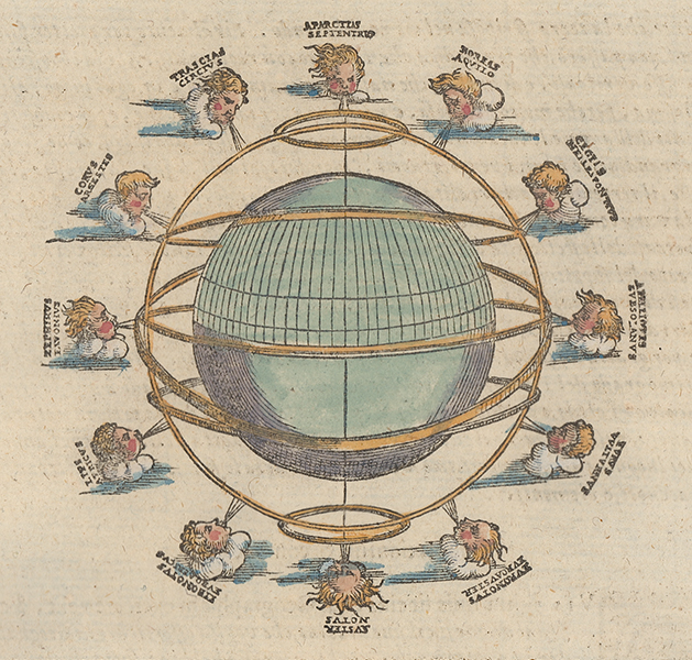
A characterful late sixteenth century model of the globe featuring twelve wind-heads, originally engraved by Porro for Giovanni Antonio Magini's 1596 reduced size edition of Claudius Ptolemy's Geographia. This particular example is from the 1621 Italian printing, the Geografia cioe Descrittione Universale della Terra, issued by the Galignani brothers in Padua. The heads themselves follow the pattern put forward by Seneca in his Naturales Quaestiones, largely ascribing Roman names to the Greek equivalents made famous by Aristotle and refined by Theophrastus and Timosthenes. In most cases, the heads feature both their Latin and Greek names. Girolamo Porro (c. 1520-1604) was an Italian engraver active in Venice and his native Padua, working predominantly as a map engraver for Tommaso Porcacchi, and Girolamo Ruscelli. Giovanni Antonio Magini (1555-1615) was an Italian scientist, cartographer, and chair of mathematics at the University of Bologna. A prominent geocentrist, he was a correspondent of many notable contemporaries, including Tycho Brahe, Kepler, and Ortelius. His commentary on Ptolemy's Geographia, with accompanying copper-plate maps by Porro, appeared in Latin in its first edition in 1596, with the first Italian translation by Leonardo Cernoti printed in 1598. Ptolemy (c. AD 100-170) was a Greek native of the Egyptian city of Alexandria, and a Roman citizen. Little is known about his life, but he is credited as the author of numerous works of mathematics, engineering, astronomy, astrology, philosophy, and geography. His most famous works were the Almagest, the Geography, and the Tetrabiblion, a triad that essentially formed the basis of Byzantine, Arabic, and European science for the next thousand years. The Geography in particular had a very long reach, being reprinted numerous times in the fifteenth and sixteenth centuries. Its most famous advocate was Columbus, who used a manuscript of the Geography to plot his western course for Asia, in the journey that resulted in the discovery of America. The work was also a major inspiration, and cartographic resource, for Munster, Mercator, and Ortelius. Condition: Italian letterpress text above, below, and on verso. |
| Framing | unmounted |
| Price | £200.00 |
| Stock ID | 53138 |