
| Method | |
| Artist | Plot, Robert |
| Published | Oxford: Printed by Leon. Litchfield, for Charles Brome at the Gun near the West-End of St. Paul's Church, and John Nicholson at the King's Arms in Little Britain, London. 1705. |
| Dimensions | Folio. 320 x 210 mm |
| Notes |
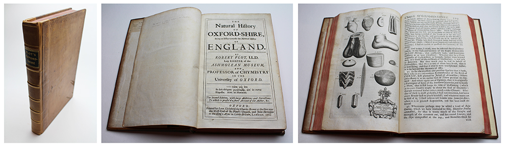
Second edition. Contemporary calf boards with gilt tooled edges, sanguine fore-edges, rebacked in 20th century tan calf with six raised bands, gilt tooled title on green calf label, tooled double fillet on compartments. Title page, dedication, iv, 366pp, large folding map of Oxfordshire and 16 (of 16) interleaved plates, v (Index). Boards slightly scuffed, time toning and manuscript annotations to forepages, small puncture to dedication, small tear to edge of folding map. Collectors' plates to pastedown for Powell Snell (18th century military poet), Robert Biddulph Phillipps (19th century antiquarian), St Michael's Monastery Belmont (20th century 'Phillipps Library' number), and 'Myers & Co. 80 New Bond Street,' the shop of bookseller Winifred Myers from 1959 to the late 1960s. The posthumous and enlarged second edition of Plot's Natural History of Oxfordshire, first issued in 1677 after three years of research and collation under the patronage of Bishop Fell and the Vice Chancellor Ralph Bathurst. Plot's aim was to produce a full survey of the natural history of England, county by county, though only two materialised, this first of Oxfordshire, and a second for Staffordshire. A third, covering Middlesex and his native Kent, was cut short by his death in 1696. Plot's Oxfordshire is most famous for the large folding map of the county Plot had engraved for the publication by the University engraver Michael Burghers. The Plot map is one of the most decorative maps of the county, with a border of 172 coats of arms, including 148 coats of arms of the county's gentry, each armourial being keyed to a numbered residence on the map. The top border contains the coats of arms of the eighteen Oxford colleges, the City, the University, and four county towns. The map is similar in scale to, but less accurate than, Robert Morden's map, which it predates by nineteen years. There are no hundreds illustrated, but rivers, towns, villages, and churches are clearly delineated, together with hills, woodlands and parks. A few roads are shown, notably the 'Akerman Street Way', making this one of the earliest English county maps to show the roads. The city of Oxford is prominently depicted with clearly illustrated towers and spires of the colleges and churches along with Folly and Magdalen bridges illustrated spanning the Thames and Cherwell. In addition to the map, Burghers engraved a suite of sixteen decorative plates, illustrating the impressive breadth of Plot's survey, and the many objects and specimens he collected, including fossils, botanical specimens, antiquities, and schematics and illustrations of unusual natural phenomena. Amongst the various items depicted is part of a colossal femur, believed by Plot to be the leg bone of a giant, now identified as the bone of a Megalosaurus and thus the earliest known engraving of a dinosaur bone. This second edition, published in 1705, was enlarged by Plot's stepson John Burman, and also includes an account of Plot's life and work by Edward Lhuyd, the Welsh natural philosopher, chemist, antiquary, and Plot's successor as Keeper of the Ashmolean. The map, despite Plot's detailed textual criticisms and suggestions for improvement, remained unchanged between the editions, as did the other engraved plates. Robert Plot (1640-1696) was an English polymath, first Professor of Chemistry at the University of Oxford and the first keeper of the Ashmolean. A prolific author and natural scientist, Plot wrote and lectured on diverse subjects, from alchemy to archaeology. His most famous publications are the two natural history surveys he produced, of Oxfordshire and Staffordshire, which were intended to be part of a complete series for the whole of England. His Natural History of Oxfordshire is particularly celebrated, not only for its fine folding map of the county, but also for Plot's discussion of marine fossils, which he considered incorrectly to be the result of mineral crystallisation rather than deriving from natural lifeforms. The success of his survey of Oxfordshire established him as one of the leading figures of England's scientific community, and his encyclopaedic knowledge earned him the moniker 'the learned Dr Plot.' Michael Burghers (1653-1727) was a Dutch engraver and printmaker. Born in Amsterdam, Burghers emigrated to England soon after 1672. He worked in Oxford, initially as Loggan's assistant from 1673, and was appointed University engraver after Loggan's death in 1692. Leonard Litchfield II (d.1685) was an Oxford-based printer and publisher, and the third in a line of publishers who served as printer to the University of Oxford. His grandfather John was University printer between 1617 and 1635, and was succeeded upon his death by his son Leonard Litchfield I (1604-1657), who was printer to the King during Charles I's residency in Oxford during the Civil War. For his involvement with the Royalist cause, his house and studio were burned by the Parliamentarians. Following the Restoration, his son, Leonard II was elevated once again to the position of printer for the University, as well as serving as yeoman bedell. He was in turn succeeded by his own son, Leonard III (fl.1710s). |
| Framing | |
| Price | £2,250.00 |
| Stock ID | 52731 |