
| Method | Copper engraved with hand colour |
| Artist | Speed, John |
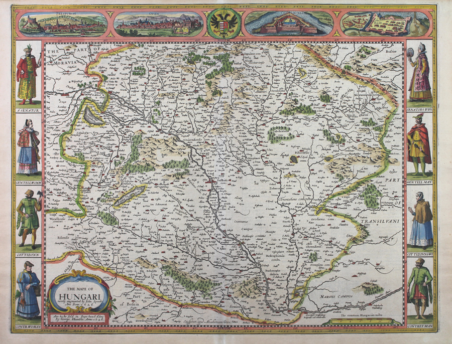
| Published | Newly augmented by Iohn Speede Ano Dom: 1626. Sculptum apud Abrahamum Goos. Are to be sold in Pops-head Alley by George Humble, Anno 1626. [London, 1631] |
| Dimensions | 392 x 510 mm |
| Notes |
John Speed's carte-a-figure map of Hungary, originally engraved by Abraham Goos in 1626. This particular example was published by George Humble in 1631 for a composite printing of Speed's county and world atlases, 'The Theatre of the Empire of Great Britaine' and 'Prospect of the Most Famous Parts of the World,' The map covers the whole of historic Hungaria, encompassing modern day Slovakia and Hungary, as well as adjoining parts of Austria, Serbia, and Romania. National borders are outlined in hand colour, and principal cities and towns, including Vienna, Bratislava, and Budapest are picked out in red. Rivers, mountains, forests, and lakes are shown pictorially, and the title is enclosed in a decoarative baroque cartouche in the bottom left corner. Along the sides of the map is an elaborate pictorial border, featuring the costume, male and female, of Hungarian Senators, Gentlefolk, Citizens, and Countryfolk. The top border encloses a series of four vignettes of the principal cities of the country, Presburgh (Bratislava), Ofen (Budapest), Comorra (Komárno), and Raab (Győr) as well as the Arms of Hungary supported by the Habsburg double eagle. John Speed (1552-1629) is the most famous of all English cartographers primarily as a result of The Theatre of the Empire of Great Britaine, the first atlas of the British Isles. The maps from this atlas are the best known and most sought-after of all county maps. The maps were derived mainly from the earlier prototypes of Christopher Saxton and John Norden but with notable improvements including parish "Hundreds" and county boundaries, town plans and embellishments such as the coats of arms of local Earls, Dukes, and the Royal Household. The maps are famed for their borders consisting of local inhabitants in national costume and panoramic vignette views of major cities and towns. An added feature is that regular atlas copies have English text printed on the reverse, giving a charming description of life in the early seventeenth century of the region. The overall effect produced very decorative, attractive and informative maps. For the publication of his prestigious atlas, Speed turned to the most successful London print-sellers of the day, John Sudbury and George Humble. William Camden introduced the leading Flemish engraver, Jodocus Hondius Sr. to John Speed in 1607 because first choice engraver William Rogers had died a few years earlier. Work commenced with the printed proofs being sent back and forth between London and Amsterdam for correction and was finally sent to London in 1611 for publication. The work was an immediate success, with the maps themselves being printed for the next 150 years. Speed was born in 1552 at Farndon, Cheshire. Like his father before him he was a tailor by trade, but around 1582 he moved to London. During his spare time Speed pursued his interests of history and cartography and in 1595 his first map of Canaan was published in the "Biblical Times". This raised his profile and he soon came to the attention of poet and dramatist Sir Fulke Greville a prominent figure in the court of Queen Elizabeth. Greville as Treasurer of the Royal Navy gave Speed an appointment in the Customs Service giving him a steady income and time to pursue cartography. Through his work he became a member of such learned societies as the Society of Antiquaries and associated with the likes of William Camden, Robert Cotton, and William Lambarde. He died in 1629 at the age of seventy-seven. Abraham Goos (c.1590-1643) was a Flemish map-maker, engraver, and publisher. Although born in Antwerp, much of his career was spent in Amsterdam, where he worked as a map engraver for his uncle Pieter van den Keere, his cousin Jodocus Hondius, and his second-cousin Jan Jansson. He is best remembered for his work on Jansson's continuations of the Mercator-Hondius Atlas Minor and for his many terrestrial and celestial globes. His son, Pieter, followed in the family business and is celebrated for his Atlas ofte Water-Weereld, the greatest maritime atlas since Lucas Janszoon Waghenaer's Thresoor der Zeevaert. Ex.Col.: László Gróf Condition: Central vertical fold, as issued. Minor time toning to margins. English text on verso |
| Framing | unmounted |
| Price | £1,650.00 |
| Stock ID | 51022 |