
| Method | Copper engraved with hand colour |
| Artist | Speed, John |
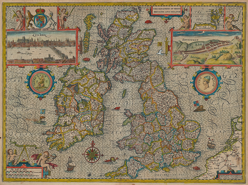
| Published | Graven by I. Hondius and are to be solde by I. Sudbury and George Humble in Popes head Alley in London. Cum privilegio Regis 1610. [London, 1627] |
| Dimensions | 380 x 510 mm |
| Notes |
A highly detailed and decorative map of the British Isles, from the third printing of John Speed's The Theatre of the Empire of Great Britaine. England, Wales, Scotland, and Ireland are divided into their counties, with the borders of each outlined in beautiful hand colour. Principal cities and towns are picked out in red, and forests, hills, and lakes are shown pictorially. The waters surrounding the islands, here named the Western Ocean, the Irish Sea, and the German Ocean, are hatchured following Hondius' traditional pattern, and sea monsters and sailing ships ply the waves. The map is further embellished with numerous decorative cartouches. In the top left and right, large boxed prospects of London and Edinburgh sit below the Royal Coat of Arms, and an inset map of the Orkney islands. Below the prospect cartouches, two roundels are suspended. Both are modelled on Roman and Celtic coins, one, showing Britannia seated on a globe and carrying a trident, very similar to Antonine bronze asses, the other featuring a portrait bust of Cunobelinus (Cymbeline). A large compass rose, a mile scale topped by a pair of cherubs, and a small strapwork cartouche containing the imprimatur complete the map. English descriptive text on verso. John Speed (1552-1629) is the most famous of all English cartographers primarily as a result of The Theatre of the Empire of Great Britaine, the first atlas of the British Isles. The maps from this atlas are the best known and most sought-after of all county maps. The maps were derived mainly from the earlier prototypes of Christopher Saxton and John Norden but with notable improvements including parish "Hundreds" and county boundaries, town plans and embellishments such as the coats of arms of local Earls, Dukes, and the Royal Household. The maps are famed for their borders consisting of local inhabitants in national costume and panoramic vignette views of major cities and towns. An added feature is that regular atlas copies have English text printed on the reverse, giving a charming description of life in the early seventeenth century of the region. The overall effect produced very decorative, attractive and informative maps. For the publication of his prestigious atlas, Speed turned to the most successful London print-sellers of the day, John Sudbury and George Humble. William Camden introduced the leading Flemish engraver, Jodocus Hondius Sr. to John Speed in 1607 because first choice engraver William Rogers had died a few years earlier. Work commenced with the printed proofs being sent back and forth between London and Amsterdam for correction and was finally sent to London in 1611 for publication. The work was an immediate success, with the maps themselves being printed for the next 150 years. Speed was born in 1552 at Farndon, Cheshire. Like his father before him he was a tailor by trade, but around 1582 he moved to London. During his spare time Speed pursued his interests of history and cartography and in 1595 his first map of Canaan was published in the "Biblical Times". This raised his profile and he soon came to the attention of poet and dramatist Sir Fulke Greville a prominent figure in the court of Queen Elizabeth. Greville as Treasurer of the Royal Navy gave Speed an appointment in the Customs Service giving him a steady income and time to pursue cartography. Through his work he became a member of such learned societies as the Society of Antiquaries and associated with the likes of William Camden, Robert Cotton, and William Lambarde. He died in 1629 at the age of seventy-seven. Jodocus Hondius (14th October 1563 - 12th February 1612) was a Dutch Flemish cartographer, engraver, and publisher. Hondius is most famous for reviving the primacy of the work of Gerard Mercator, through the publication of his Atlas, and the smaller Atlas Minor, in the early seventeenth century, at a time when cartography was largely dominated by Ortelius' Theatrum Orbis Terrarum. The Mercator-Hondius Atlas was composed of maps pulled from plates Hondius had purchased from Mercator's grandson, as well as thirty-six new plates Hondius commissioned, and in many cases engraved, himself. He is also believed to have been the chief engraver of the plates for John Speed's Theatre of the Empire of Great Britaine. Following his death, he was succeeded by his sons, Jodocus the Younger and Henricus, as well as his son in law Jan Jansson. Condition: Central vertical fold, as issued. Minor time toning, ink stains, and creases to edges of sheet, not affecting map. Two small burn holes to margins. English letterpress text with hand coloured initial to verso. |
| Framing | mounted |
| Price | £3,000.00 |
| Stock ID | 53437 |