
| Method | Copper engraved |
| Artist | [Jefferys, Thomas] |
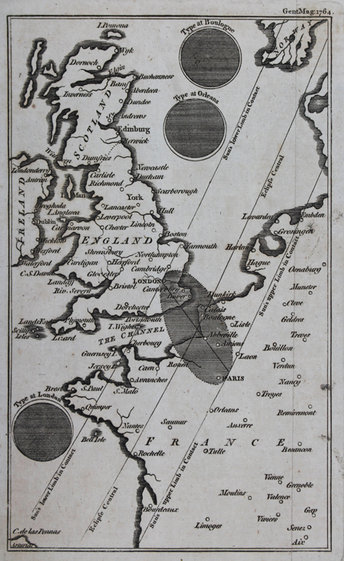
| Published | Gent. Mag. 1764 |
| Dimensions | 190 x 114 mm |
| Notes |
A map of the British isles and western sections of France, Belgium, the Netherlands, Denmark, and Norway, illustrating the path of the solar eclipse of 1764, engraved for The Gentleman's Magazine: and Historical Chronicle, most likely by Thomas Jefferys. The map is bisected by the central line of the eclipse, along with the sun's lower and upper limbs in contact. The shadow of the eclipse between London and Paris is marked as a hatched oval, and a trio of diagrams demonstrate its appearance at greatest extent when viewed from Boulogne-sur-Mer (the centre of the eclipse), Orleans (the sun's upper limb), and London (the sun's lower limb). Thomas Jefferys (c.1719-1771), was an English cartographer and one of the leading map suppliers of his day. He engraved and printed maps for government and other official bodies and produced a wide range of commercial maps and atlases, especially of North America. As "Geographer to the Prince of Wales", he produced 'A Plan of all the Houses, destroyed & damaged by the Great Fire[ [...]. He also produced 'The Small English Atlas' with Thomas Kitchin, and engraved plans of towns in the English Midlands. In 1754, Jefferys published a map of Virginia which had been surveyed by Joshua Fry and Peter Jefferson in 1751. The next year he published a 'Map of the Most Inhabited Part of New England' surveyed by John Green, and in 1768 he published 'A General Topography of North America and the West Indies' in association with Robert Sayer. In 1775, after his death, collections of his maps were published by Sayer as 'The American Atlas and The West-India Atlas'. Condition: Vertical fold, as issued. Binders holes to left margin, not affecting map. Blank on verso. |
| Framing | framed |
| Price | £175.00 |
| Stock ID | 51006 |