
| Method | Copper engraved |
| Artist | Saxton, Christopher |
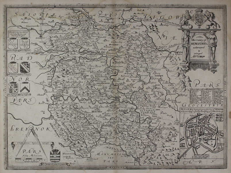
| Published | Christophorus Saxton descripsit [c.1693 Impression] |
| Dimensions | 375 x 500 mm |
| Notes |
The third state of Christopher Saxton's landmark map of the county of Hereford, this particular example published by Philip Lea in his second printing of Saxton's atlas, under the title Shires of England and Wales. The original plate was engraved by Remigius Hogenberg for inclusion in the original Saxton atlas of 1579, but the plate was altered twice before the current state, firstly for a publication around 1665 by an unknown publisher that never came to fruition. Shirley suggests that publication may have either been suspended due to the Plague of 1665, or, more dramatically, burned in the Great Fire on 1666. The only change made to the plate between the Web printing of 1645 and Lea's edition of 1689 is the addition of the letters 'C.R.' [Carolus Rex] above the Royal coat of arms, and the addition of a boxed map of the City of Hereford in the bottom right corner, essentially a copy of that appearing on the Speed map of Herefordshire. A note above the city map describes the demolition of the suburbs of Hereford by the Scottish army during the siege of 1644. The second major change, as here, was the addition of the roads following the surveys of Ogilby, which Lea inserted for his editions of c.1693. Christopher Saxton (c.1540 - c.1610) was a British estate surveyor and draughtsman, best known for his maps of English counties. Apprenticed to the cleric and cartographer John Rudd, Saxton developed the skills to become the man now known as 'the father of English cartography'. Under the patronage of Thomas Seckford, Saxton carried out an extensive topographical survey of England and Wales during the years 1573-1578. 34 county maps based on the surveys were engraved between 1574 and 1578 by Remy Hogenberg, Lenaert Terwoort, Cornelis de Hooghe, Augustine Ryther, Francis Scatte, and Nicholas Reynolds, forming the first atlas of England and Wales. The work was the basis for many later maps. The maps were issued by Saxton in untitled volumes from 1579, and subsequently reissued as The Shires of England and Wales, by William Web in 1645, by Philip Lea (with added maps) and in a French edition Atlas Anglois in 1693, by G Willdey in 1732, by T Jefferys in 1749, and finally as a wall map of England and Wales in 20 Sheets in c. 1770. Philip Lea (fl.1683-1700) was a British map maker, globe maker, engraver, and publisher, as well as a manufacturer of scientific and cartographic instruments. The majority of his maps were reworkings of plates purchased from many of the leading map engravers of his day, including Saxton, Ogilby, Moll, Morden, and Overton. As well as his work as a map maker, Lea also collaborated with Robert Morden on a series of views of London, which customers were able to purchase printed on silk if so desired. Remigius Hogenberg (c.1536-c.1588) was a Flemish engraver and draughtsman, active in London from the early 1570s. The brother of the more well-known Frans Hogenberg who, with Georg Braun, published the Civitates Orbis Terrarum, Remigius is best known for engraving a number of plates for the Saxton atlas of the counties of England and Wales. Condition: Central vertical fold as issued. Minor waterstaining to margins, and top and bottom of map. Blank on verso. |
| Framing | unmounted |
| Price | £750.00 |
| Stock ID | 45390 |