
| Method | Copper engraved |
| Artist | Ogilby, John |
| Published | By John Ogilby Esqr. His Ma.ties Cosmographer [London, 1675] |
| Dimensions | 330 x 440 mm |
| Notes |
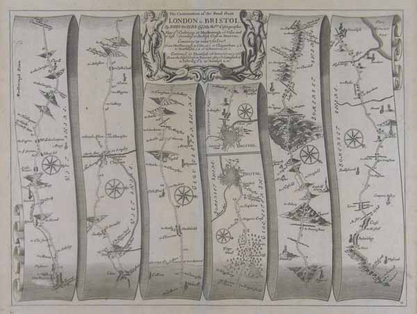
A strip map of the continuation of the road from London to Bristol, this particular sheet showing the route from Marlborough to Huntspil. Bristol is depicted at centre, and the map details numerous other cities, towns, and villages, including Studley, Chippenham, Marshfield, Axbridge, and Crose, as well as the Mendip Hills. The map is further ornamented with numerous compass roses, and a decorative title cartouche. John Ogilby, born in Edinburgh in 1600, was a man of many parts, his various vocations included dancing instructor, tutor, theatre owner, translator, poet, printer, historian and mapmaker. He did not embark on his last profession until he was over sixty years of age but in the short time before his death in 1675 he achieved lasting fame with his great work on the English roads, 'Britannia', published the year he died. It proved to be a milestone in English cartography, the first real step forward since the publication of Saxton's atlas in 1579. The atlas had an immediate influence on the work of the London publishers; it was used as a reference for the addition of the roads to many extant plates, for example in the later editions of Saxton and Speed, and for new sets of county maps such as those by Robert Morden in the 1695 edition of Camden's 'Britannia'. Ogilby and his team surveyed seventy-two of the major roads in England and Wales and published the results of their surveys on one hundred folio sheets on a scale of one inch to one mile. Each of the maps covers the distance of about sixty to seventy miles and the longer routes are divided into four or five sheets. The maps followed an entirely new concept with the roads being displayed in the shape of ribbons, some six or seven to a sheet, each with its own compass, with a title cartouche that was either ornamental or pictorial. The maps were engraved to show whether the roads were fenced or unfenced, whilst the hills were drawn in such a manner as to differentiate for the traveller the degree and direction of slope. There is an abundance of other detail such a villages, churches, parks, gentlemen's seats, bridges, rivers, ponds, woods and commons, windmills and gallows. Finally the iconography of each of the towns and cities on route is carefully delineated. The atlas was also of historical importance for Ogilby ignored local tradition and standardised the English mile throughout his book at 1,760 yards where it remains to this day. The two editions of the 'Britannia' in 1675 and 1698 meant that the atlas had a relatively short life but there were many derivatives from it early in the next century, when it was published in an abridged version by a number of publishers including Owen and Bowen, Gardner and Senex. Of particular interest are the four maps illustrating the surveyors at work. One man is pushing a measuring wheel, one revolution of which was equivalent to half a pole of 8 1/2 feet, the number of revolutions being registered in a dial near the handle, whilst a rider on horseback carries a quadrant and a cherubic boy holds a section of the surveyor's chain. Condition: Central vertical fold as issued. Minor abrasion to surface of sheet, just below the entry for Marlborough. Minor time-toning. |
| Framing | mounted |
| Price | £250.00 |
| Stock ID | 41025 |