
| Method | Copper engraved with hand colour |
| Artist | Collins, Greenvile |
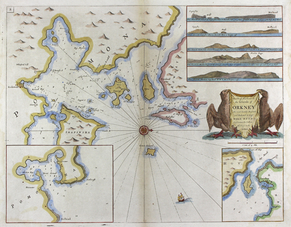
| Published | Are most humbly Presented and Dedicated to Capt. Will Bond by Capt. Greenvile Collins, Hydrogr. to the King [London, c.1693] |
| Dimensions | 445 x 565 mm |
| Notes |
A large and impressive sea chart of the harbours of the Orkney islands, from Capt. Greenvile Collins' Great Britain's Coasting Pilot. The map shows depth soundings, anchorages, the directions of tides, shoals, reefs, harbours, and settlements. In the top right corner, a set of five inset views show the topography of the coastline. The title is enclosed in a banner cartouche held between a pair of sea-eagles, and a compass rose is included at centre. Great Britain's Coasting Pilot was first published in 1693, and sold by Richard Mount of London. Commissioned by King Charles II, the collated charts represent a significant achievement in hydrography for they instantly superseded the outmoded Dutch charts on which Britain had been previously reliant. The remarkable archive of this point in naval history confirms that the Collins charts were frequently mentioned as the best available for many years after their publication. In the century to follow Collins' charts were reissued over twenty times without revision. Captain Greenvile Collins (fl.1669 - 1696) began his career as an Officer in the Royal Navy, and was first recognised for an expedition to the coasts of South America with Sir John Narborough. In 1683, Charles II appointed Collins to the role of Hydrographer to the King and placed him in command of the Royal yacht, Merlin. The Merlin is cited as the first British warship dedicated to marine survey work, as opposed to exploration, as Greenville was subsequently appointed by Samuel Pepys to record the coastline of Britain. Condition: Central vertical fold, as issued. Minor waterstaining and time toning to edges of sheet. Blank on verso. |
| Framing | unmounted |
| Price | £300.00 |
| Stock ID | 50416 |