
| Method | Copper engraving |
| Artist | Jodocus Hondius |
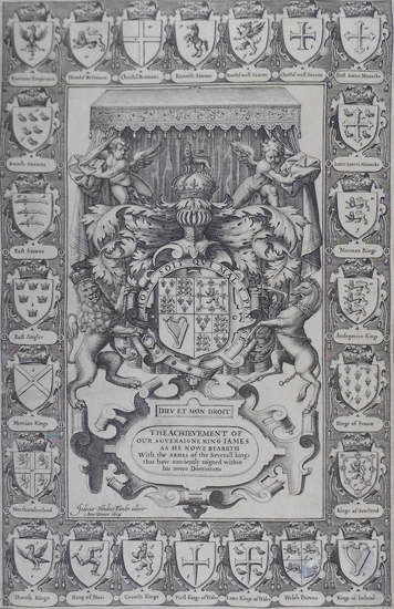
| Published | Jodocus Hondius Flander cælavit Anno Domini 1614. (London: Sudbury & Humble, c.1614.) |
| Dimensions | Image 374 x 235 mm, Sheet 380 x 241 mm |
| Notes |
The frontispiece to John Speed's The Theatre of the Empire of Great Britaine. The central panel contains the Royal Arms, allegorical motifs and a dedication to James I. Surrounding this are twenty-four smaller shields which depict early English monarchs and historical realms. These include heraldry which denotes the Romans, Normans, Danes, Andegavians, as well as various branches of Saxony. John Speed (1552 - 1629) is the most famous of all English cartographers primarily as a result of The Theatre of the Empire of Great Britaine, the first atlas of the British Isles. The maps from this atlas are the best known and most sought-after of all county maps. The maps were derived mainly from the earlier prototypes of Christopher Saxton and Robert Morden but with notable improvements including parish "Hundreds" and county boundaries, town plans and embellishments such as the coats of arms of local Earls, Dukes, and the Royal Household. The maps are famed for their borders consisting of local inhabitants in national costume and panoramic vignette views of major cities and towns. An added feature is that regular atlas copies have English text printed on the reverse, giving a charming description of life in the early seventeenth century of the region. The overall effect produced very decorative, attractive and informative maps. For the publication of this prestigious atlas Speed turned to the most successful London print-sellers of the day, John Sudbury and George Humble. William Camden introduced the leading Flemish engraver, Jodocus Hondius Sr. to John Speed in 1607 because first choice engraver William Rogers had died a few years earlier. Work commenced with the printed proofs being sent back and forth between London and Amsterdam for correction and was finally sent to London in 1611 for publication. The work was an immediate success and the maps themselves being printed for the next 150 years. Condition: Trimmed to image. Patched hole to lower right of sheet, effecting lower right quarter of shield along bottom, second in from right. Small tear to bottom right corner. |
| Framing | unmounted |
| Price | £200.00 |
| Stock ID | 38887 |