
| Method | Copper engraved |
| Artist | Galle, Philips after Ortelius, Abraham |
| Published | [Philips Galle. Antwerp, c.1577-1588] |
| Dimensions | 78 x 108 mm |
| Notes |
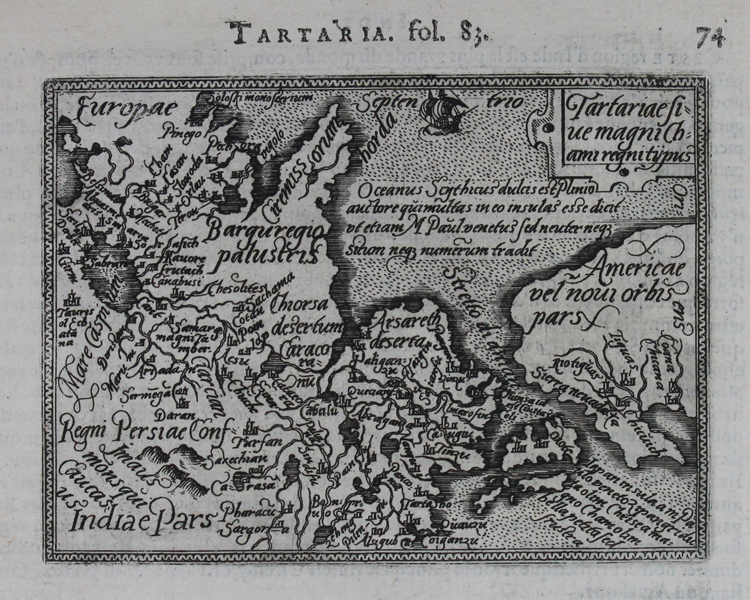
A fascinating miniature map of the Tartar Kingdom, stretching from Asian Russia across to the Northwest coast of America, featuring one of the earliest depiction's of the peninsular of California, the islands of Japan are plotted in the semi-mythical 'Straits of Anian'. Title in a decorative cartouche and a detailed sailing ship feature in the top right corner. From a French printing of the first Galle edition of the Epitome of Ortelius' Theatrum Orbis Terrarum. The Epitome was the first miniature atlas ever published, and, like the Theatrum Orbis Terrarum on which it was based, was an immediate success. The first edition, published by Galle in 1577, was entitled Spieghel der Wereld. In 1588, Galle published a revised and improved second edition, under the title Epitome du Theatre du Monde, with a new series of much finer miniature maps. The third edition, inspired by Galle's success, featured a new set of maps engraved by the brothers Arsenius, who, alongside Galle, had previously engraved plates for Ortelius' original Theatrum. Philips Galle (1537 - 1612) was a Dutch engraver, printmaker, and publisher, particularly celebrated for his reproductive engravings of original works by Hieronymus Cock, Maarten van Heemskerck, Johannes Stradanus, and other Dutch and Flemish masters. Galle's success as an engraver and published put him in close contact with many of the late sixteenth century's most important figures, including Ortelius, for whom he produced numerous plates, Christopher Plantin and the Familia Caritatis, and his students Hendrick Goltzius, Adriaen and Jan Collaert, and Karel van Mallery. Following his work on Ortelius' Theatrum Orbis Terrarum, Galle produced a series of miniature maps after Ortelius' originals, which he published, potentially without the permission of Ortelius, as the Spieghel der Wereld, the first miniature atlas. Abraham Ortelius (1527 -1598) was a Flemish cartographer, cosmographer, geographer and publisher and a contemporary of Gerard Mercator, with whom he travelled through Italy and France. Although it is Mercator who first used the word "Atlas" as a name for a collection of maps, it is Ortelius who is remembered as the creator of the first modern atlas. Theatrum Orbis Terrarum was the first systematically collated set of maps by different map makers in a uniform format. Three Latin editions as well as a Dutch, French and German edition of Theatrum Orbis Terrarum were published by 1572 and a further 25 editions printed before Ortelius' death in 1598. Several more were subsequently printed until around 1612. Ortelius is said to have been the first person to pose the question of the continents once being a single land mass before separating into their current positions. Condition: Excellent impression with full margins. French text on verso. |
| Framing | mounted |
| Price | £300.00 |
| Stock ID | 44492 |