
| Method | Copper engraved with hand colour |
| Artist | Porro, Girolamo after Magini, Giovanni Antonio |
| Published | [Venice, c. 1598] |
| Dimensions | 125 x 172 mm |
| Notes |
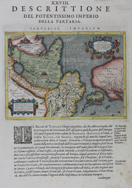
A map depicting the Tartaric influence in parts of Asia, Europe and North America from Giovanni Antonio Magini's edition of Claudius Ptolemy's Geographia, published c. 1598. the map is decorated with two cartouches. The entire map is criss-crossed by numerous rhumb-lines. The Italian text below and on verso provides an account of navigation and Tatar history. Inscription above print: 'Descrittione Del Potentissimo Imperio Della Tartaria'. Girolamo Porro (c. 1520-1604) was an Italian engraver active in Venice and his native Padua, working predominantly as a map engraver for Tommaso Porcacchi, and Girolamo Ruscelli. Giovanni Antonio Magini (1555-1615) was an Italian scientist, cartographer, and chair of mathematics at the University of Bologna. A prominent geocentrist, he was a correspondent of many notable contemporaries, including Tycho Brahe, Kepler, and Ortelius. His commentary on Ptolemy's Geographia, with accompanying copper-plate maps by Porro, appeared in Latin in its first edition in 1596, with the first Italian translation by Leonardo Cernoti printed in 1598. Condition: Good impression. Light foxing to margins. |
| Framing | unmounted |
| Price | £450.00 |
| Stock ID | 43098 |