
| Method | Woodcut with hand colour |
| Artist | Fries, Lorenz after Waldseemüller, Martin |
| Published | [Vienne, 1541] |
| Dimensions | 430 x 312 mm |
| Notes |
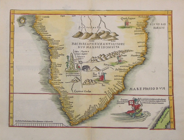
An attractive example of Lorenz Fries' reduced edition of Waldseemüller's seminal 1513 woodcut map of southern Africa, this example from a later printing of the 1541 fourth edition of Fries' Ptolemaic Atlas, with text by Michael Servetus. Waldseemüller's original was the very first separate map of southern Africa to be published, depicting the discoveries of the Portuguese at the beginning of the sixteenth century, and has come to be recognised as one of the author's most important contributions to the history of cartography. Fries' map was first published in Strasbourg by Johann Gruninger in 1522, and while retaining Waldseemüller's cartography, embellishes his design with the addition of three enthroned African Kings, a pair of serpentine dragons and a basilisk, an elephant, and, most distinctively, a large portrait of the Portuguese King Emanuel riding a sea monster in the bottom right corner, in acknowledgement of the map's Portuguese sources. Apart from these fantastical additions, the centre of the African continent is largely devoid of detail, with only the putative Mountains of the Moon and the source of the Nile listed. By contrast, the coastline is very well detailed, with numerous place-names reflecting the increase in maritime interest in the area by the European kingdoms. Fries' maps were published in four different editions, by Gruninger in Strasbourg in 1522 and 1525, and, following Fries' death in 1532, by Johann Trechsel in Lyon and Vienne in 1535 and 1541. The Trechsel editions featured text by the Spanish humanist, Michael Servetus, writing in this case under the name Villanovus. Unfortunately for Servetus, his theological treatises drew negative attention from Protestant and Catholic corners alike, and in 1553 he was found guilty of heresy and burned at the stake, and this put paid to any future editions of Fries' atlas. The woodcut borders on the versos of Gruninger and Trechsel's editions are traditionally attributed to Hans Holbein and Durer respectively. The current example is something of an anomaly, as its lack of a title above the map block is consistent with earlier impressions, though the fact that the block has a prominent crack in the bottom right corner suggests it can only be a later impression from the final 1541 fourth edition printed in Vienne. Lorenz Fries (c.1490-1532) was born in the Alsace region and studied variously at the universities in Pavia, Vienna, Piacenza and Montpellier. After completing his studies, Fries set himself up as a physician in Alsace, and briefly in Switzerland, before finally settling in Strasbourg in 1519, by which point he had published several medical texts. It was in Strasbourg that Fries meet Johann Gruniger, an associate of the St. Die group of scholars who included Martin Waldseemüller. From 1520 to 1525 Fries worked with Gruniger as his cartographic editor, producing numerous reduced woodblock maps using the vast material of Waldseemüller's 1513 Ptolemaic Atlas. Martin Waldseemüller (11th September, 1470 - 16th March, 1520) was a German author, cartographer, and publisher, and one of the most significant figures in the history of cartography. His most celebrated achievement was the publication in 1507 of his Universalis Cosmographia, a monumental twelve-panel map of the world making use of the discoveries of Columbus and Vespucci, and being the first recorded use of the title 'America' to describe the New World. In addition to this, Waldseemuller's appendix to his Ptolemaic atlas featured some of the very first individual maps of European discoveries in the New World, East Indies, and Western and Southern Africa. Norwich, Maps of Africa, 150 Condition: Central vertical fold as issued. Light time toning to fold. |
| Framing | unmounted |
| Price | £1,600.00 |
| Stock ID | 36086 |