
| Method | Copper engraved with hand colour |
| Artist | Blaeu, Willem Janszoon and Blaeu, Johannes |
| Published | Guiljelmus Blaeu. [Joan Blaeu, Amsterdam, c.1640] |
| Dimensions | 410 x 540 mm |
| Notes |
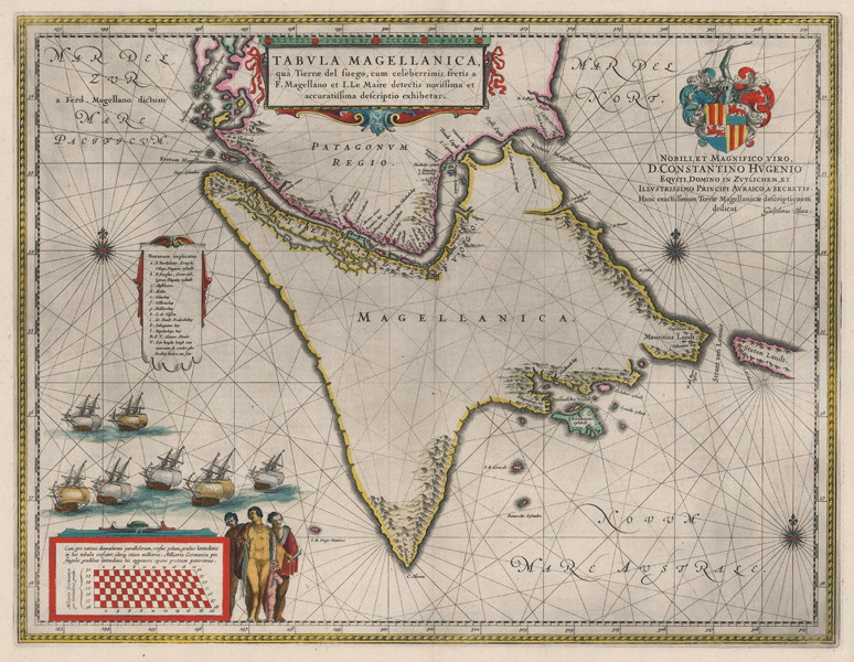
A large and decorative early seventeenth century map of the Tierra del Fuego and the Straits of Magellan, with specific mention of the newly discovered Le Maire Strait, from a Dutch edition of Blaeu's Atlas Novus. The map shows the southern extremities of the American continent, with Patagonia and the northern coast of the Tierra del Fuego mapped in detail. The rest of the Tierra del Fuego is less well mapped, with Blaeu relatively conservatively representing it as a large pointed island extending to Cape Horn, rather than the complex archipelago we now know it to be. The mountains of the region, so often mentioned by early navigators, are dotted along the eastern and southern coast, and on the opposite side of the Le Maire Strait, the eastern extent of Staten Landt (modern Isla de los Estados) is left unmapped. The discovery of the Strait by Le Maire and Schouten in 1616 had a profound effect on Spanish control of the Pacific, allowing rival navies to bypass the treacherous Straits of Magellan and proving that the Tierra del Fuego was an island, rather than joined to the unknown southern continent. The map is further embellished by a series of cartouches, containing the title, an explanatory note of locations in the Tierra del Fuego, an illustration of the distortion caused by the Mercator projection at the extremities of the globe, and a large dedicatory coat of arms for the poet and polymath Constantijn Huygens. Rhumb lines criss-cross the seas from three compass roses, a fleet of Dutch ships ply the waves of the southern Pacific, and a group of Patagonian 'giants' stand in the bottom corner, nude except for their cloaks. The Blaeu family were one of the most famous publishers of maps, globes and atlases during the seventeenth-century. Cartographers, globe makers and booksellers, the Blaeu business flourished in Amsterdam for over 40 years, until a fire destroyed their premises in 1672. They lost all of their plates, prints and stock, which effectively ruined the firm. Willem Blaeu founded the business in 1596. It initially functioned as a globe and instrument makers, but soon expanded into maps, topography and sea charts. The Atlas Novus was Willems great work; a major work which intended to include the most up-to-date maps of the entire world. He issued the first two volumes in 1635, but died in 1638 before the atlas was completed. The running of the business was passed on to his sons Johannes and Cornelis, in addition to the role of the official cartographer of the East India Company. After the death of Cornelis in 1644, Johannes continued the business alone and established his own reputation as a great mapmaker. Johannes completed his father's grand project in 1655 with the sixth and final volume of the Atlas Novus. He also produced the Tooneel der Steden van der Vereenighde Nederlanden in 1649-1653, as well as a similar set of Italian town plans which were published in 1663. Condition: Central vertical fold, as issued. Minor foxing to margins, not affecting map. Dutch text on verso. |
| Framing | unmounted |
| Price | £800.00 |
| Stock ID | 51945 |