
| Method | Copper engraved with hand colour |
| Artist | Homann, Johann Baptist |
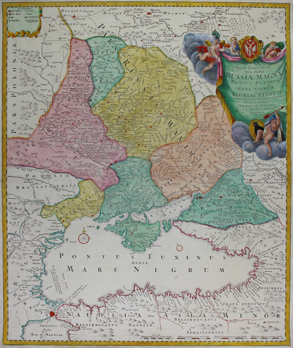
| Published | A Ioh. Baptista Homanno, Sac. Caes. Majestatis Geographo. Noribergae [Nuremberg, c.1740] |
| Dimensions | 580 x 485 mm |
| Notes |
A large and impressive mid-eighteenth century map of the Black Sea and modern day Ukraine, originally issued by Johann Baptist Homann during the reign of Peter the Great to illustrate Russian imperial ambitions in the region, this example published posthumously by the Homann Heirs for the Maior Atlas Superiore. The map encompasses the area between the Black Sea coast of Turkey to Moscow, and from the borders of Poland in the west to the Caucasus in the east. The map is ornamented in full and beautiful hand colour, principal cities and towns are picked out in red, and mountains ranges are depicted pictorially. Earlier printings of this map featured crossed-sword icons to illustrate important battles between Russia and its Swedish, Tartar, and Cossack rivals. In the top right corner of the map, a large decorative cartouche in the form of a banner encloses the title, surmounted by the Russian Imperial Arms and supported by a group of martially-attired cherubs. Johann Baptist Homann (20th March 1664 - 1st July 1724) was a German engraver and cartographer, and the Imperial Geographer to the Holy Roman Emperor Charles VI. In 1702 he opened a publishing house in Nuremberg, and his maps often make reference to his membership of the Prussian Royal Academy of Sciences and his imperial patronage. Upon his death, his maps passed to the Homann Heirs company and reprinted many times before the company closed in 1848. Condition: Central horizontal fold, as issued. Minor creasing to central fold. Blank on verso. |
| Framing | unmounted |
| Price | £475.00 |
| Stock ID | 51068 |