
| Method | Woodcut with hand colour |
| Artist | Fries, Lorenz after Waldseemüller, Martin |
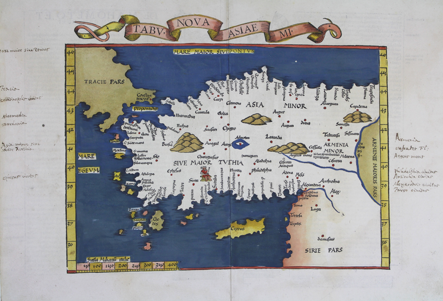
| Published | [Melchior and Gaspar Trechsel, Lyon, 1535] |
| Dimensions | 305 x 380 mm |
| Notes |
An attractively hand coloured example of Lorenz Fries' reduced edition of Waldseemüller's 1513 woodcut map of Turkey, this example the 1535 printing by the Lyonnais publishers Melchior and Gaspar Trechsel. The banner above the map describes it as a 'new' map of Asia Minor, as the block was originally cut to be used in an abandoned 'Chronica Mundi' of modern maps intended as a contrast to Waldseemüller's Ptolemaic maps. The map encompasses the whole of Asia Minor from the Euphrates to the Aegean, and from the Black Sea to Syria. Cyprus and Rhodes are prominently shown, as well as a number of the other islands of the Dodecanese and northern Aegean. Thrace and Armenia are presented in full wash colour, as are the seas and waterways of the region, and mountains are shown pictorially. A seated king is pictured above Attalea (modern Antalya), perhaps representing Attalus II of Pergamon, or potentially the early bishopric of Attalea, as the city was prominent in the early spread of Christianity in the region. In the left and right margins, manuscript annotations in an old hand note key geographic features and cities of the region, with a particular focus on its classical history. On the verso, a lengthy history of the Ottoman sultans is bordered by decorative column ornaments traditionally ascribed to Hans Holbein. Fries' maps were published in four different editions, by Gruninger in Strasbourg in 1522 and 1525, and, following Fries' death in 1532, by Johann Trechsel in Lyon and Vienne in 1535 and 1541. The Trechsel editions featured text by the Spanish humanist, Michael Servetus, writing in this case under the name Villanovus. Unfortunately for Servetus, his theological treatises drew negative attention from Protestant and Catholic corners alike, and in 1553 he was found guilty of heresy and burned at the stake, and this put paid to any future editions of Fries' atlas. The woodcut borders on the versos of Gruninger and Trechsel's editions are traditionally attributed to Hans Holbein and Durer respectively. Lorenz Fries (c.1490-1532) was born in the Alsace region and studied variously at the universities in Pavia, Vienna, Piacenza and Montpellier. After completing his studies, Fries set himself up as a physician in Alsace, and briefly in Switzerland, before finally settling in Strasbourg in 1519, by which point he had published several medical texts. It was in Strasbourg that Fries meet Johann Gruniger, an associate of the St. Die group of scholars who included Martin Waldseemüller. From 1520 to 1525 Fries worked with Gruniger as his cartographic editor, producing numerous reduced woodblock maps using the vast material of Waldseemüller's 1513 Ptolemaic Atlas. Martin Waldseemüller (11th September, 1470 - 16th March, 1520) was a German author, cartographer, and publisher, and one of the most significant figures in the history of cartography. His most celebrated achievement was the publication in 1507 of his Universalis Cosmographia, a monumental twelve-panel map of the world making use of the discoveries of Columbus and Vespucci, and being the first recorded use of the title 'America' to describe the New World. In addition to this, Waldseemuller's appendix to his Ptolemaic atlas featured some of the very first individual maps of European discoveries in the New World, East Indies, and Western and Southern Africa. Condition: Central vertical fold, as issued. Marginal annotations in sepia ink. Minor time toning to edges of sheet. Verdigris from blue, yellow, and red hand colour on verso. |
| Framing | unmounted |
| Price | £950.00 |
| Stock ID | 50183 |