
| Method | Woodcut |
| Artist | Fries, Lorenz after Waldseemüller, Martin |
| Published | Johannies Grieningerus communibus Johannis Koberger excudebat MDXXV [Strassburg, 1525] |
| Dimensions | 300 x 438 mm |
| Notes |
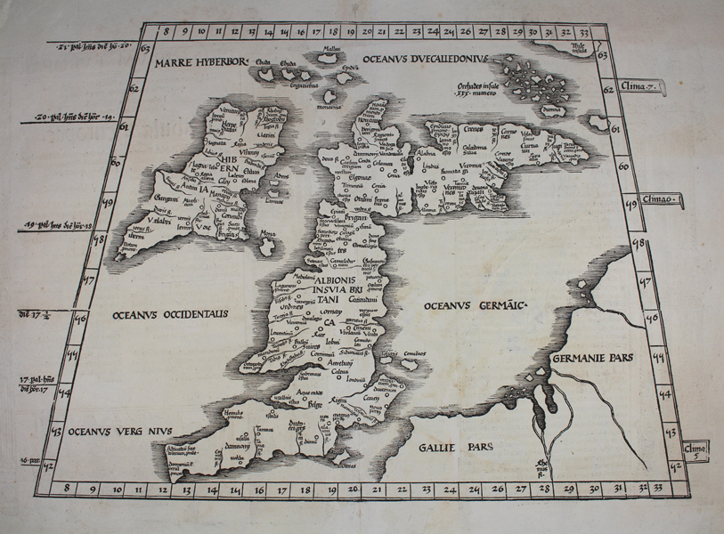
An attractive example of Lorenz Fries' reduced edition of Waldseemüller's 1513 woodcut map of Ptolemaic Britain, this example the 1525 printing by Gruninger. The map is enclosed in a trapezoidal border, with zonal notations to left and right and increments marked along the top and sides. The map retains the distinctive right angled kink for Scotland, Ireland is depicted as exaggeratedly northern, and Cornwall is greatly elongated. The isle of Anglesey (Mona) is equidistant between Wales and Ireland, while in the extreme right corner of the plate, the mythical island of Thule can be seen. By the time of the map's production, the Classical Thule had largely become conflated with Scandinavia. Textually, the map retains classical labels, mixing Celtic and Roman place names and tribal regions. Hadrian's wall is marked in the North as a simple dashed line. Adjacent parts of Germania and Gallia are shown in rudiment. On the verso, two panels describing the history and geography of the British Isles are enclosed by decorative border ornaments traditionally ascribed to Hans Holbein. Fries' maps were published in four different editions, by Gruninger in Strasbourg in 1522 and 1525, and, following Fries' death in 1532, by Johann Trechsel in Lyon and Vienne in 1535 and 1541. The Trechsel editions featured text by the Spanish humanist, Michael Servetus, writing in this case under the name Villanovus. Unfortunately for Servetus, his theological treatises drew negative attention from Protestant and Catholic corners alike, and in 1553 he was found guilty of heresy and burned at the stake, and this put paid to any future editions of Fries' atlas. The woodcut borders on the versos of Gruninger and Trechsel's editions are traditionally attributed to Hans Holbein and Durer respectively. Lorenz Fries (c.1490-1532) was born in the Alsace region and studied variously at the universities in Pavia, Vienna, Piacenza and Montpellier. After completing his studies, Fries set himself up as a physician in Alsace, and briefly in Switzerland, before finally settling in Strasbourg in 1519, by which point he had published several medical texts. It was in Strasbourg that Fries meet Johann Gruniger, an associate of the St. Die group of scholars who included Martin Waldseemüller. From 1520 to 1525 Fries worked with Gruniger as his cartographic editor, producing numerous reduced woodblock maps using the vast material of Waldseemüller's 1513 Ptolemaic Atlas. Martin Waldseemüller (11th September, 1470 - 16th March, 1520) was a German author, cartographer, and publisher, and one of the most significant figures in the history of cartography. His most celebrated achievement was the publication in 1507 of his Universalis Cosmographia, a monumental twelve-panel map of the world making use of the discoveries of Columbus and Vespucci, and being the first recorded use of the title 'America' to describe the New World. In addition to this, Waldseemuller's appendix to his Ptolemaic atlas featured some of the very first individual maps of European discoveries in the New World, East Indies, and Western and Southern Africa. Shirley 17 Condition: Excellent clean impression on full sheet. Central vertical fold as issued. Professional tear repairs to the blank space in the German Ocean. |
| Framing | framed |
| Price | £1,800.00 |
| Stock ID | 46171 |