
| Method | Steel engraving |
| Artist | Monin, Charles V. |
| Published | A Paris, Chez Hoquart, Marchand d'Estampes, Rue St. Jacques 64. [1839] |
| Dimensions | Image 445 x 605 mm, Sheet 503 x 700 mm |
| Notes |
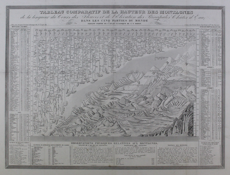
A large-scale fold out comparative table of the world's mountains, rivers, and waterfalls, derived from Bulla's 1826 chart, the author of the first table in this format. The finely engraved rivers, mountains, and waterfalls are fully annotated with numbered keys and descriptive text in French,surrounding the image. The chart was published in C.V. Monin's 'Atlas Classique De La Geographie Ancienne, Du Moyen Age Et Moderne, A l'Usage des Colleges et des Pensions, Pour Servir A L'Etude De La Geographie Et De L'Histoire, Par V. Monin, Ingenieur-Geographe, Membre De La Societe De Geographie.' Charles V. Monin (fl. c.1830-c.1880) was a nineteenth century French cartographer and publisher working in Paris and Cean. He was a member of the 'Société de Géographie' in Paris and published a number of maps and atlases including 'The Small National Atlas of the departments of France and its colonies' of 1835, 'The Universal Atlas of Ancient, Medieval and Modern Geography' of 1838/9, and the 'Globe' of 1875. Condition: Pressed vertical and horizontal folds as issued. Some light wear to folds. |
| Framing | unmounted |
| Price | £300.00 |
| Stock ID | 45499 |