
| Method | Copper engraved with original hand colour |
| Artist | Froggett, John Walter |
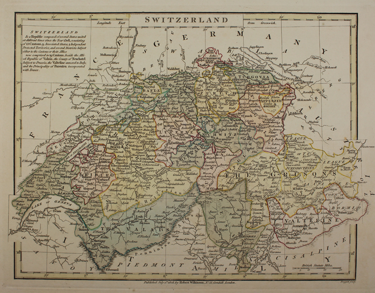
| Published | Froggett Sculp. Published July 1st. 1808, by Robert Wilkinson, No.58, Cornhill, London. |
| Dimensions | 225 x 300 mm |
| Notes |
An early nineteenth century map of Switzerland, engraved by Froggett for Wilkinson's General Atlas of the World, Quarters, Empires, Kingdoms, States &c. with Appropriate Tables. The map is presented in full original hand colour, with the Cantons and the Allied Republic of the Valais in wash colour. Valteline, annexed to Italy, the County of Neuchatel, subject to Prussia, and the Principality of Porentru, incorporated with France, is shown in outline colour. John Walter Froggett (fl.1805-1835) was a British mapmaker. Robert Wilkinson (c.1760-1825) was a British cartographer and publisher. The majority of his maps were derived from those of John Bowles (c.1701-1779), whose plates he acquired following the latter's death. His most famous and successful publication was Wilkinson's General Atlas of the World, though he also published a late edition of Bowen and Kitchin's Large English Atlas, as well as a number of smaller atlases by other mapmakers, and separately published maps of his own creation. Following his death in 1825, the majority of his plates and stock, including the General Atlas, were bought and republished by William Darton. Condition: Minor time toning to sheet. Some verdigris from old colour on verso. |
| Framing | unmounted |
| Price | £75.00 |
| Stock ID | 48790 |