
| Method | Copper engraved with early hand colour |
| Artist | Bowen, Emanuel and Bowen, Thomas |
| Published | By Eman. Bowen, Geographer to His late Majesty, & Thos. Bowen. Printed for Thomas Kitchin at No. 59 Holborn Hill, London. [1767] |
| Dimensions | 230 x 325 mm |
| Notes |
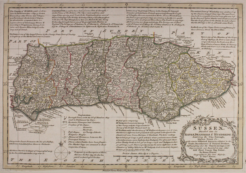
Full title: 'Sussex, Divided into its Rapes, Deanries & Hundreds; Exhibiting the City, Borough, Market Towns &c. with concise Historical Extracts, relative to its Trade, Manufactures & Natural Produce. Distinguishing also the Church Livings, with Improvements not Inserted in any other Half Sheet County Map Extant.' A scarce and incredibly detailed county map of Sussex, decorated with a strap work cartouche and compass rose. Short but detailed descriptions of the key towns of the county are featured, as well as a key corresponding to features including rectories and vicarages, post stages, battles, market days, and religious houses. Engraved by Emanuel and Thomas Bowen this map is generally regarded as a reduced version of the large-scale map of the county published in Emanuel's "The Large English Atlas". Drawn from contemporary sources this map was published by Thomas Kitchin in 'Atlas Anglicanus, Or a Complete Sett of Maps of the Counties of South Britain...' Bowen, Emmanuel (c.1693-1767) One of the leading 18th-century map and print sellers and engravers in London. Appointed Engraver of maps to George II of England and possibly Louis XV of France. His apprentices included Thomas Kitchin and Thomas Jeffreys. Collaborated with other map makers of his time, including the Bowles family and John Owen. Thomas Kitchin (1718-1784) was one of the best and most prolific engravers of the eighteenth century. He issued The General Atlas, Describing the Whole Universe , first published in 1773, and regularly reissued thereafter. His work also included a large number of maps of the English counties, particularly for the London Magazine (1747-1760), the Universal Magazine (1747-1766), and for Dodsley's England Illustrated (1764). Other maps were published in conjunction with Emanuel Bowen in the Large English Atlas and the Royal English Atlas (1763). Condition: Central vertical fold, as issued. Mount stain from previous mount to margins, not affecting map. |
| Framing | unmounted |
| Price | £150.00 |
| Stock ID | 48153 |