
| Method | Copper engraved |
| Artist | van den Keere, Pieter |
| Published | 1627 |
| Dimensions | 84 x 115 mm |
| Notes |
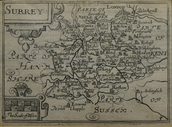
A miniature map of the county of Surrey, engraved by Pieter van den Keere, from 'England, Wales, Scotland, and Ireland Described'. Keere's maps of the counties of England and Wales, as well as his regional maps of Scotland and Ireland, were originally begun in 1599, shortly after the engraving of a large number of plates of the rest of the world that appeared originally in Barent Lagenes and Cornelis Claesz' Caert-thresoor, and it is likely that the British maps were intended for a British volume of this same series. As it was, the maps were not published until 1617, when Willem Blaeu issued them with Latin text in his Guiliemi Camdeni Britannia in epitomen contracta, a miniature epitome of Camden's celebrated Britannia. By 1619, the plates had passed from Blaeu to George Humble, who retitled them in English and reissued them with English verso text for his miniature edition of Speed's Theatre of Great Britaine and Ireland. Once retitled in English, the plates underwent relatively few revisions. After the publication of England, Wales, and Ireland: the severall counties in 1619, Humble moved his plate numbers from the lower left to the lower right of the plates and reissued the atlas in 1627 under the slightly different title England Wales Scotland and Ireland described, which was retained in subsequent printings by William Humble, Roger Rea, and Bassett & Chiswell. The atlas was a significant commercial success, and as such the maps are often referred to as 'miniature Speeds' by modern collectors, despite the fact that the maps themselves are reductions of the Saxton maps of the counties, and in some instances predate Speed's plates by at least a decade. Pieter van den Keere (1571-c.1646), also known frequently as Petrus Kaerius, came to England in 1584, as a Protestant refugee from his home town of Ghent with his sister Colette, who married Jodocus Hondius in 1587. It was probably from Hondius that Keere learned to engrave. Both engravers left London in 1593 to settle in Amsterdam. His first set of miniature maps were produced for the Middelburg publisher Cornelis Claesz, for inclusion in Barent Langenes' Caert Thresoor. Keere began to engrave a series of miniature maps in 1599 in preparation for a small atlas of the British Isles. The maps were first published in 1617 by William Blaeu with plate numbers and Latin text. They then passed to George Humble, who published them in 1619 and then again in 1627, by which time they had become known colloquially as 'Miniature Speeds.' |
| Framing | unmounted |
| Price | £175.00 |
| Stock ID | 22639 |