
| Method | Copper engraved |
| Artist | Van Langeren, Jacob |
| Published | c.1643 |
| Dimensions | 100 x 102 mm |
| Notes |
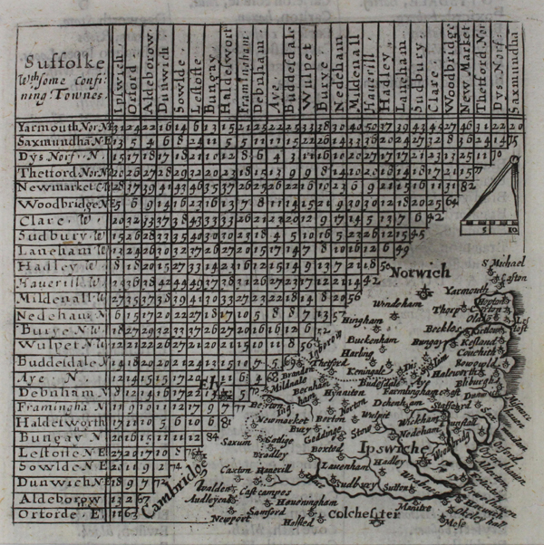
A scarce map of Suffolk, with a distance chart, from Thomas Jenner's printing of 'A Direction for the English Traviller'. The earlier thumbnail county map of the first edition has been erased to be replaced by a new map on a larger scale which now gives town names in full together with many towns in neighbouring counties. Interestingly this is one of the few county maps published in England during the Civil war. Thomas Jenner, a Puritan parliamentarian, reissued Van Langeren's maps with improvements in 1643, believing the maps and distance charts would be of assistance to the Parliamentarian army in the field. Van Langeren's 'A Direction for the English Traviller' was first published in 1635, and was the first pocket-sized road atlas. The left hand upper diagonal half of each map plate is occupied by a triangular table of distances copied from John Norden's 'England and Intended Guide, for English Travellers' published in 1625. The signature of Jacob van Langeren appears on the title page of the work and he is credited with the engraving of the maps. Van Langeren is not recorded as having visited England - the plates for the English Traviller therefore were presumably engraved by him in his home town of Brussels. It is likely that Van Langeren's original thumbnail county maps were influenced by William Bowes' series of playing card maps that were published in 1590. re were presumably engraved by him in his home town of Brussels. It is likely that Van Langeren's original thumbnail county maps were influenced by William Bowes' series of playing card maps that were published in 1590. Condition: Excellent impression on the full sheet with title above and town names engraved below. |
| Framing | mounted |
| Price | £120.00 |
| Stock ID | 42762 |