
| Method | Copper engraved with hand colour |
| Artist | Cantelli da Vignola, Giacomo |
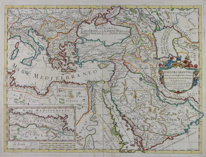
| Published | E di nuovo dissegnata, et accomodata all'Idioma Italiano, da Giacomo Cantelli da Vignola. E data in luce da Gio. Giacomo Rossi, in Roma, alla Pace, con Pr. del S.P. 1679. Giorgio Widman Sculp. |
| Dimensions | 420 x 570 mm |
| Notes |
A late seventeenth century map of the Ottoman Empire, from Giacomo de Rossi's rare atlas Mercurio Geografico. The maps for de' Rossi's atlas were designed by Giacomo Cantelli da Vignola after Nicolas Sanson. The plate for this particular map was engraved by Giorgio Widman. The map shows the whole of the Eastern Mediterranean, stretching from the borders of France and Tunisia in the west to the frontiers of the Persian Empire and the Caspian in the east. National and regional borders are outlined in hand colour, an rivers, mountains, lakes, and forests are shown pictorially. Within the empire of the Sultan, or 'Grand Turk' as he is here, are numerous 'Beglierbati' - an Italian rendering of the Turkish beylerbey - a title used to signify an Ottoman governor general and his jurisdiction. Their use in this map is relatively anachronistic, as the beylerbeyliks had begun to be replaced in an administrative capacity from the late sixteenth century by the eyalets. In the bottom left corner, an inset boxed map extends the coast of north Africa to encompass further regions within the Ottoman sphere of influence: the Kingdom of Fez (modern Morocco), Algeria, Tunisia, and Tripoli (modern Libya). The map is completed by a large decorative title cartouche, topped by a pair of supporters in Ottoman dress who hold a Turban above the Ottoman crescent. Giacomo Cantelli da Vignola (1643-1695) was an Italian geographer and cartographer, principally known for producing maps for Giacomo de' Rossi. Later in life he served as court geographer to the Duke of Modena, Francesco II d'Este. Giovanni Giacomo de' Rossi (1627-1691) was an Italian engraver, publisher, and author. A scion of the prominent Rossi family of publishers, he was the elder son of the printwork's founder Guiseppe de' Rossi, who opened his printery in 1633 near the church of Santa Maria della Pace. Giovanni, like other members of his family, not only produced his own plates, but also printed a wide array of works by other Italian printmakers and cartographers. Under Giovanni Giacomo and his son Domenico, the workshop reached its zenith, with father and son working on engravings on many diverse subjects, but with a speciality in publishing works of antiquarian interest. Following Domenico's death, the Rossi printshop became the Calcographia Camerale, then the Regia Calcographia, and finally the current Calcographia Nazionale. Nicholas Sanson d'Abbeville (1600-1667) was a French engraver and cartographer, and Geographer to Louis XIII and Louis XIV. As well as world maps, he also issued a series of historic maps to accompany popular classical texts like Caesar's Gallic Wars. After his death, he was succeeded by his sons Adrien and Guillaume, who frequently signed their work Sanson fils. Condition: Central vertical fold, as issued. Splitting, creasing, and repaired tears to central margin. Creasing to sheet. Two large oil stains to Libyan desert at left and Arabian desert at right. Minor chips, creases, and tears to margins. Blank on verso. |
| Framing | unmounted |
| Price | £700.00 |
| Stock ID | 51044 |