
| Method | Copper engraved with hand colour |
| Artist | Lea, Philip and Saxton, Christopher |
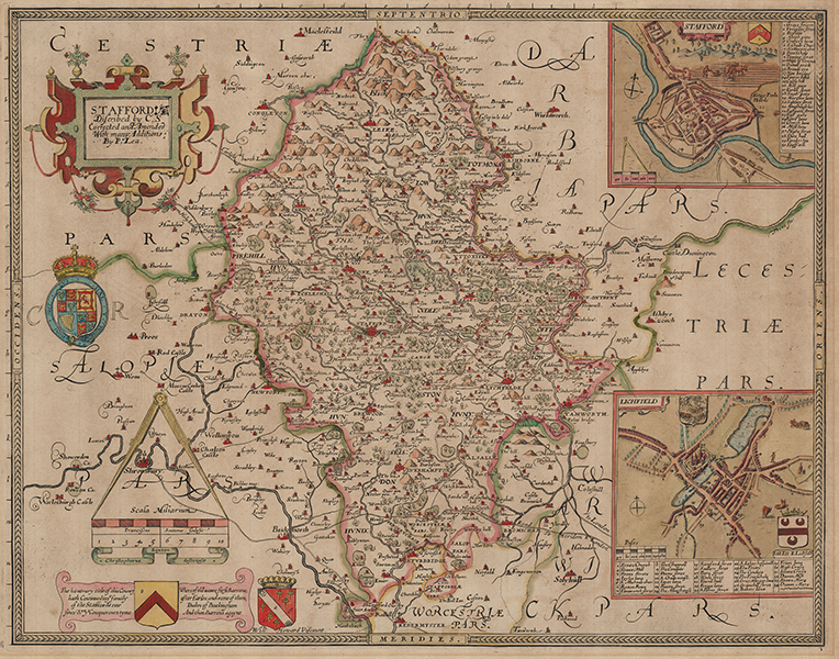
| Published | Christophorus Saxton descripsit. [London, c.1690] |
| Dimensions | 390 x 500 mm |
| Notes |
A scarce map of the county of Staffordshire, issued from the original Saxton plate reworked and corrected by Philip Lea. The map shows the county, as well as adjoining parts of Cheshire, Shropshire, Derbyshire, Leicestershire, Warwickshire, and Worcestershire, with details depicting towns, churches, forests, hills, and rivers. Aside from the addition of the Roads, the mapping of the county itself is relatively untouched from Saxton's original, though the rest of the plate has been extensively reworked. Saxton's original title cartouche in the upper left has been retitled, below which a royal crest with the initials 'CR' - Charles Rex, has been added, and a banner at bottom left contains a descriptive text about the Earls of Stafford. In place of the royal crest and the arms of Thomas Seckford, Master of the Court of Requests, on the original Saxton plate, Lea has added a pair of boxed city plans of Stafford and Lichfield after Speed. Lea acquired and reissued Saxton's plates with corrections and amendments between 1683 and 1693. After his death, the plates passed to his wife Anne, before being bought at auction by George Willdey after her death, most likely in 1730. From 1732, Willdey offered reissues of the maps, though it does not appear that he ever issued them as complete atlases. Christopher Saxton (c.1540-c.1610) was a British estate surveyor and draughtsman, best known for his maps of English counties. Apprenticed to the cleric and cartographer John Rudd, Saxton developed the skills to become the man now known as 'the father of English cartography'. Under the patronage of Thomas Seckford, Saxton carried out an extensive topographical survey of England and Wales during the years 1573-1578. 34 county maps based on the surveys were engraved between 1574 and 1578 by Remy Hogenberg, Lenaert Terwoort, Cornelis de Hooghe, Augustine Ryther, Francis Scatte, and Nicholas Reynolds, forming the first atlas of England and Wales. The work was the basis for many later maps. The maps were issued by Saxton in untitled volumes from 1579, and subsequently reissued as The Shires of England and Wales, by William Web in 1645, by Philip Lea (with added maps) and in a French edition Atlas Anglois in 1693, by G Willdey in 1732, by T Jefferys in 1749, and finally as a wall map of England and Wales in 20 Sheets in c.1770. Philip Lea (fl.1683-1700) was a British map maker, globe maker, engraver, and publisher, as well as a manufacturer of scientific and cartographic instruments. The majority of his maps were reworkings of plates purchased from many of the leading map engravers of his day, including Saxton, Ogilby, Moll, Morden, and Overton. As well as his work as a map maker, Lea also collaborated with Robert Morden on a series of views of London, which customers were able to purchase printed on silk if so desired. George Willdey (1676-1737) was a British printer, mapseller, instrument maker, and dealer in luxury items and miscellanies. His most notable cartographic contribution was the reissuing of Saxton's county maps, the plates for which he had purchased at auction from the estate of Anne Lea, the wife of the mapmaker and publisher Philip Lea. Condition: Central vertical fold, as issued. Time toning to sheet. Acid burn from old mount to margins and verso. Blank on verso. |
| Framing | unmounted |
| Price | £1,200.00 |
| Stock ID | 53422 |