
| Method | Steel engraved with original hand colour |
| Artist | Rapkin, John |
| Published | John Tallis & Company, London & New York. The Illustrations by A.H. Wray & Engraved by J. Rogers. The Map Drawn & Engraved by J. Rapkin. [c.1856] |
| Dimensions | 240 x 320 mm |
| Notes |
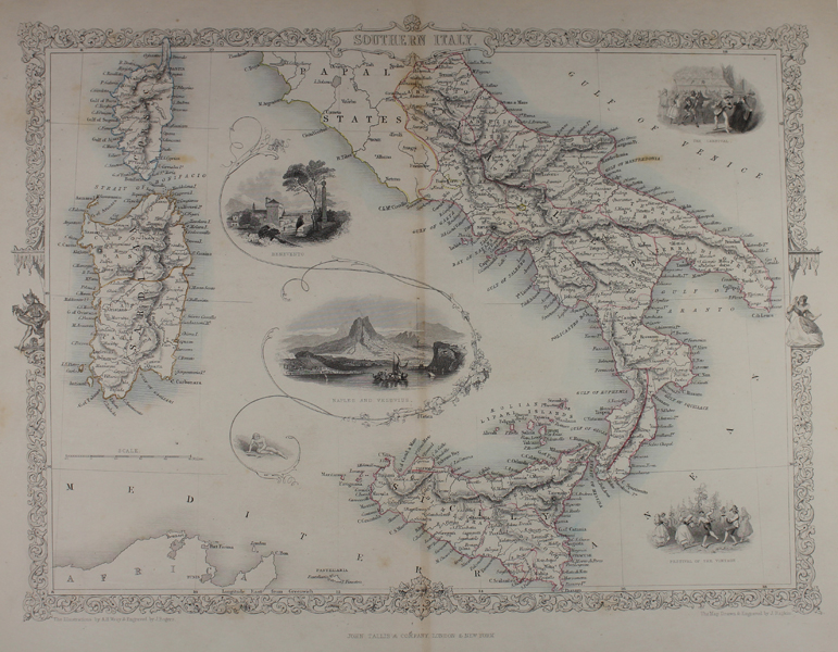
A decorative map of the kingdom of the Two Sicilies, as well as adjoining parts of the Papal States, Corsica, Sardinia, and North Africa, surrounded by vignettes including Benevento, Naples and Mount Vesuvius, and illustrations of Carnival and the Festival of the Vintage. The whole is enclosed in one of Rapkin's signature decorative borders flanked by commedia dell'arte figures. John Tallis was a British publisher and one of the most popular cartographers of the 19th Century. Tallis maps were highly valued for their accuracy, but perhaps more so for their charming vignettes and ornamentation. Engraved by John Rapkin, these maps were praised by the New York Sun as "the most accurate and most splendid publication of the kind ever issued". The Bristol Times observed that Mr. Tallis maps "are not only critically correct, but are accompanied with elegant and appropriate engravings illustrative of the manners and costumes of the different countries." John Rapkin was an engraver and mapmaker active in Britain in the mid-nineteenth century. He drew and engraved the maps for John Tallis' 'The Illustrated Atlas and Modern History of the World' (1845-51), which was later re-issued by the London Printing and Publishing Company. He also drew and engraved maps for R. Montgomery Martin's 'British Colonies, their history' (1849), and Wright's 'Universal Pronouncing Dictionary' (c.1850). Condition: Central vertical fold as issued. Minor time toning to margins, and to central fold. |
| Framing | unmounted |
| Price | £110.00 |
| Stock ID | 48355 |