
| Method | Copper engraved with hand colour |
| Artist | Morden, Robert |
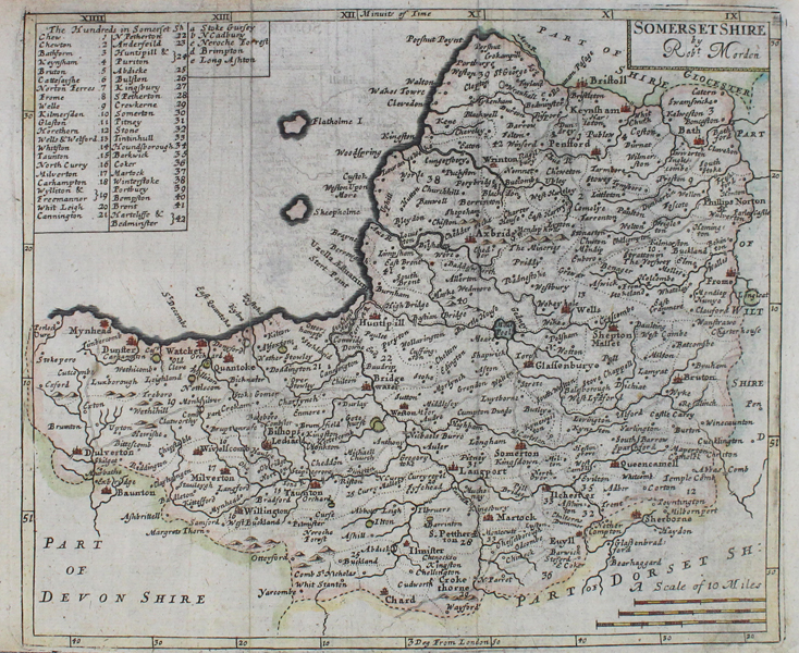
| Published | [London, c. 1701] |
| Dimensions | 175 x 205 mm |
| Notes |
A map of Somerset, from a series of maps referred to as 'miniature Mordens'. The series of 'miniature Mordens' were first published in 1701 in 'The New Description and State of England, containing the Mapps of the Counties of England and Wales, in Fifty Three Copper-Plates...'., with a second edition being issued in 1704, with no alterations to the plates. In 1708, the maps were republished in 'Fifty Six new and acurate maps of Great Britain , Ireland and Wales'. This particular edition saw alterations being carried out by Herman Moll, the most significant of which was the addition of compass-indicators. Other changes included those to roads and town-symbols. Without any further alterations, the maps were featured in 'Magna Britannia et Hibernia', an atlas published in monthly issues between 1720 and 1731. Although the maps are often thought to be reduced versions of those by Morden featured in Gibson's 1695 edition of Camden's 'Britannia', it is possible that that the smaller maps were drawn, and perhaps even engraved, prior to 1693. Robert Morden (c. 1650-1703) was an English bookseller and publisher, as well as an accomplished geographer and cartographer. He is best known for a series of maps issued in 1695 in Gibson's revised edition of Camden's Brittannia,' engraved by Sutton Nichols. Condition: Trimmed within plate mark. Two vertical folds as issued. Slight discolouration and worn paper. |
| Framing | mounted |
| Price | £140.00 |
| Stock ID | 43031 |