
| Method | Copper engraved with hand colour |
| Artist | Hondius, Henricus |
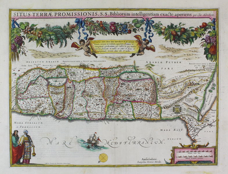
| Published | Amsteldami, Sumptibus Henrici Hondius. Sculpserunt Everardus Sim. Hamersveldt et Salomon Rogeri. [c.1630] |
| Dimensions | 370 x 494 mm |
| Notes |
A highly decorative map of the 'Promised Land,' depicting the Levantine coast and parts of modern-day Egypt, Israel, Palestine, and Jordan, from the Hondius Atlas. The map is oriented with East to top. The holy land is divided into the lands of the biblical tribes, the borders of which are outlined in hand colour. The map combines contemporary seventeenth century geographical knowledge with biblical geography. The path of the Israelites in the Exodus is depicted, as well as various events like the destruction of Pharaoh's army in the Red Sea, and various conflicts, like those between the Jews and Gentiles, are shown as vignettes of clashing armies. The debauched cities of Sodom and Gemorrah are depicted as flaming ruins in the Dead Sea, and a ship and sea creature off the coast of Palestine likely represents the beginning of the story of Jonah and the Whale. The top of the plate is decorated with an elaborate garland of ribbons, flowers, and fruit, which sits above a pair of cherubs carrying a banner with a description of the Holy Land as a place of 'figs and pomegranates, olive oil and honey.' In the bottom left corner of the map, Moses and Aaron are depicted, the former carrying the tablet of the Ten Commandments. Opposite them, in the right corner, a strapwork cartouche encloses a scale in miles. Henricus Hondius (1597 - 16th August 1651), often called Hendrik Hondius the Younger to differentiate him from the earlier, and unrelated portrait engraver Hendrik Hondius the Elder, was the son of the famous cartographer Jodocus Hondius. Like his father, Henricus was an engraver, cartographer, and publisher. He first came to prominence through his publication in 1606 of a new version of Mercator's 1569 World Map, the plates for which he had obtained from Mercator's grandson Rumold. Following his father's death, Henricus co-ran the family business, eventually partnering with his brother-in-law, Jan Jansson. Evert Symonsz. van Hamersvelt (1591-1653) was a Dutch engraver based in Amsterdam. A prolific map engraver, he produced numerous cartographic plates for Jodocus Hondius, Jan Jansson, and Johan Blaeu, most notably for later editions of the Mercator-Hondius Atlas and for Jansson's Atlas Novus. Gerard Mercator (1512 - 1594) originally a student of philosophy was one of the most renowned cosmographers and geographers of the 16th century, as well as an accomplished scientific instrument maker. He is most famous for introducing Mercators Projection, a system which allowed navigators to plot the same constant compass bearing on a flat map. His first maps were published in 1537 (Palestine), and 1538 (a map of the world), although his main occupation at this time was globe-making. He later moved to Duisburg, in Germany, where he produced his outstanding wall maps of Europe and of Britain. In 1569 he published his masterpiece, the twenty-one-sheet map of the world, constructed on Mercator's projection. His Atlas, sive Cosmographicae Meditationes de Fabrica Mundi, was completed by his son Rumold and published in 1595. After Rumold's death in 1599, the plates for the atlas were published by Gerard Jr. Following his death in 1604, the printing stock was bought at auction by Jodocus Hondius, and re-issued well into the seventeenth century. Jodocus Hondius (14th October 1563 - 12th February 1612) was a Dutch Flemish cartographer, engraver, and publisher. Hondius is most famous for reviving the primacy of the work of Gerard Mercator, through the publication of his Atlas, and the smaller Atlas Minor, in the early seventeenth century, at a time when cartography was largely dominated by Ortelius' Theatrum Orbis Terrarum. The Mercator-Hondius Atlas was composed of maps pulled from plates Hondius had purchased from Mercator's grandson, as well as thirty-six new plates Hondius commissioned, and in many cases engraved, himself. He is also believed to have been the chief engraver of the plates for John Speed's Theatre of the Empire of Great Britaine. Following his death, he was succeeded by his sons, Jodocus the Younger and Henricus, as well as his son in law Jan Jansson. Johannes Janssonius (1588 - 1664) was a famed cartographer and print publisher. More commonly known as Jan Jansson, he was born in Arnhem where his father, Jan Janszoon the Elder, was a bookseller and publisher. In 1612 he married the daughter of the cartographer and publisher Jodocus Hondius, and then set up in business in Amsterdam as a book publisher. In 1616 he published his first maps of France and Italy and from then onwards, produced a very large number of maps which went some way to rival those of the Blaeu family, who held a virtual monopoly over the industry. From about 1630 to 1638 he was in partnership with his brother-in-law, Henricus Hondius, issuing further editions of the Mercator/Hondius atlases to which his name was added. On the death of Hondius he took over the business, expanding the atlas still further, until eventually he published an eleven volume Atlas Major on a scale similar to Johannes Blaeu's magnum opus. After Jansson's death, his heirs published a number of maps in the Atlas Contractus of 1666, and, later still, many of the plates of his British maps were acquired by Pieter Schenk and Gerard Valck, who published them again in 1683 as separate maps. Condition: Excellent impression with wide margins. Repaired and pressed centre fold. German text on verso. |
| Framing | unmounted |
| Price | £800.00 |
| Stock ID | 42735 |