
| Method | Offset lithograph |
| Artist | [Anonymous] |
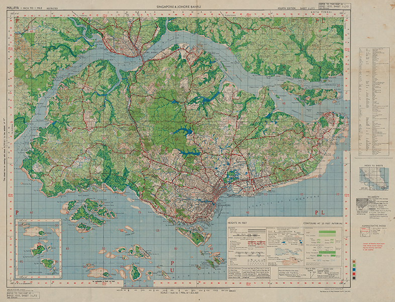
| Published | Published by Survey Production Centre, A.L.F.S.E.A., 1945. 4th Edition. Revised by 7 Ind Air Survey Company., I.E. Reproduced by IIO Map Production Company R.E. |
| Dimensions | 550 x 760 mm |
| Notes |
A highly detailed map of the island of Singapore printed on the eve of liberation from Japanese occupation, published just two months before the end of the Syonan period. The map was compiled by the Geographical Section of the General Staff of the British Army, and became the standard issue map in the planning for Operation Tiderace, which, alongside Operation Zipper for Malaya, aimed to reestablish British control in the region following Emperor Hirohito's announcement on the 15th of August 1945 of the intended Japanese surrender. The map shows the entirety of the island, as well as the adjoining parts of Johore Bahru on the Malayan mainland, and an inset boxed map in the bottom left shows Sudong, Pawai, and Senang islands, as well as Raffles Lighthouse. The map is incredibly detailed, with individual buildings and houses shown outside of the grid plan of the centre. Topographical details, such as jungle and tree coverage, elevations, water features, plantations and cultivated land, railways, roads, bridges, and municipal buildings, are all mapped, corresponding to a large key in the bottom right. Condition: Horizontal and vertical folds, as issued. Minor staining and time toning to folds and margins. Blank on verso. |
| Framing | unmounted |
| Price | £1,500.00 |
| Stock ID | 53430 |