
| Method | Copper engraved with hand colour |
| Artist | Rocque, John and Parr, Richard |
| Published | R. Parr sculp / Published according to act of Parliament by I. Rocque next ye Duke of Graftons Head near Hide Park Corner [c. 1746] |
| Dimensions | 490 x 620 mm |
| Notes |
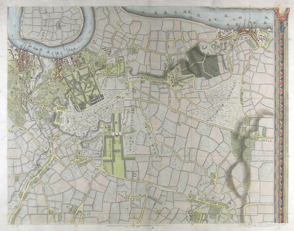
A large-scale map of the London Boroughs of Deptford, Lewisham, Greenwich, Blackheath, Woolwich and the Isle of Dogs, with all major buildings clearly plotted, the Royal Hospital and Greenwich Park prominent to the top left and Wricklemarsh House set in its landscaped park to the centre (Rocque has misnamed it Ridley Marsh). The curve of the Thames, dotted with ships, and the dockyards at Deptford and Woolwich, line to top of the map. A sheet from An exact survey of the cities of London and Westminster, the Borough of Southwark, with the country near ten miles round, engraved by Richard Parr and first published by John Rocque in 1746. The sixteen sheet map, printed inside a decorative border, was published in several editions until his death in 1762. In the late 1760s, the plates were transferred to the publishers Carrington Bowles and Robert Sayer by Rocque's widow Mary Ann, who continued to print new editions. Richard Parr (fl. 1832-1839) was an etcher and reproductive engraver. In his early career he produced plates after prominent Victorians. He engraved John Rocque's 1746 sixteen sheet map An exact survey of the cities of London and Westminster, the Borough of Southwark, with the country near ten miles round. John Rocque (1709-1762) was a Hugenot refugee who came to England as a baby in 1709 with his parents, fleeing persecution in France. In addition to his work as surveyor and mapmaker, Rocque was an engraver and map-seller. He was also involved in gardening as a young man, living with his brother Bartholomew, who was a landscape gardener, and producing plans for parterres, perhaps recording pre-existing designs, but few details of this work are known. Rocque produced engraved plans of the gardens at Wrest Park (1735), Claremont (1738), Charles Hamilton's naturalistic landscape garden at Painshill Park, Surrey (1744), Wanstead House (1745) and Wilton House (1746). Rocque is now mainly remembered for his Map of London, published in twenty four sheets in 1746. It was by far the most detailed map of London published up to that time, and remains the most detailed map of eighteenth century London today. Rocque also published another smaller-scale map of London in sixteen sheets at the same time. His success as a cartographer brought him the appointment as cartographer to Frederick, Prince of Wales in 1751. A fire in 1750 destroyed his premises and stock, but by 1753 he was employing ten draughtsmen, and published The Small British Atlas: Being a New set of Maps of all the Counties of England and Wales. Rocque's 1756 map of Dublin featured on an Irish ten pound bank note. He married twice. His widow continued the business after his death. Condition: Vertical fold in centre, as issued. Squaring up and scaling in pen and brown ink. Inscriptions in margins, not affecting printed map. Old repairs to margins and top left corner of map. |
| Framing | unmounted |
| Price | £350.00 |
| Stock ID | 41912 |