| Method | Steel engraved with hand colour |
| Artist | Nicollet, H. |
| Published | Compose et dessine par H. Nicollet. Le Texte et les Fig. Suppl. par E. Soulier. Publie par J. Andriveau-Goujon, Rue du Bae, No. 21. Paris, 1854. |
| Dimensions | 470 x 580 mm |
| Notes |
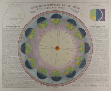
A large mid nineteenth century French map showing the annual revolution of the Earth around the Sun, from Jean Andriveau-Goujon's 'Atlas classique et universel de geographie ancienne et moderne, contenant les decouvertes et les divisions les plus nouvelles dans les cinq parties du monde pour servir a la lecture des voyages, des ouvrages historiques et des meilleurs traites de geographie.' The borders of the circle are divided into the months and the signs of the zodiac, with a diagram of the Earth at each of the 12 stations showing the position of the north pole and night and day throughout the year. The sun is shown slightly off centre, and a pair of axes show the equinoxes and solstices. The remaining space between the sphere and the chart's border is occupied by two large panels of explanatory text in French. H. Nicollet (fl.1850s) was a French engraver and map maker. Jean Andriveau-Goujon (fl.1850s) was the founder of a French publishing house and mapmakers. His son Gilbert-Gabriel Andriveau-Goujon and his grandson Eugene Andriveau-Goujon succeeded him in the family business. Condition: Central vertical fold, as issued. Minor time toning and creasing to margins. Blank on verso. Framed in black box frame. |
| Framing | framed |
| Price | £375.00 |
| Stock ID | 50600 |

