
| Method | Copper engraved with hand colour |
| Artist | Homann Heirs |
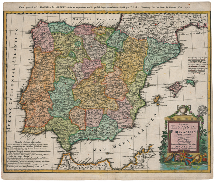
| Published | Edentibus Homannianis Haeredibus MDCCLXXXII Cum Gratia ac Privil. Sacr. Caes. Majest. [Nuremberg, 1782] |
| Dimensions | 475 x 590 mm |
| Notes |
A large and impressive late-eighteenth century map of Spain and Portugal, published by the Homann Heirs for the Maior Atlas Superiore following the cartography of Franz Ludwig Güssefeld. The map is presented in full hand colour, and principal cities are picked out in red. The Iberian peninsula is divided up into provinces, and adjoining parts of France and North Africa are outlined in hand colour. A mile scale is included above the Balearic islands, and the title is enclosed in a large decorative cartouche surrounded by emblems of the Empire's wealth. The Lopez mentioned in the inscription is most likely the Spanish cartographer Tomas Lopez de Vargas Machuca (1730-1802), who studied in Paris under d'Anville. A superscript title in French reads: 'Carte general d'Espagne et de Portugal divisee en ses provinces actuelles par D.T. Lopez, nouvellement dressee par F.L.G. a Nuremberg chez les Heret de Homann l'an 1782. ' Johann Baptist Homann (20th March 1664 - 1st July 1724) was a German engraver and cartographer, and the Imperial Geographer to the Holy Roman Emperor Charles VI. In 1702 he opened a publishing house in Nuremberg, and his maps often make reference to his membership of the Prussian Royal Academy of Sciences and his imperial patronage. Upon his death, his maps passed to the Homann Heirs company and reprinted many times before the company closed in 1848. Franz Ludwig Güssefeld (1744-1807) was a German cartographer, who drafted over 100 maps for the Homann Heirs and is widely credited with having saved the company through his contributions. Condition: Central vertical fold, as issued. Central horizontal creasing. Collectors stamp above title cartouche. Trimmed close to neatline at left and right, as issued. Minor time toning and marginal tears to edges of sheet. Rust stain from old paper inclusion to top right margin, not affecting map. Blank on verso. |
| Framing | unmounted |
| Price | £400.00 |
| Stock ID | 51670 |