
| Method | Copper engraved with hand colour |
| Artist | Allard, Carel |
| Published | J. Covens and C. Mortier, Amsterdam c. 1721 |
| Dimensions | 495 x 580 mm |
| Notes |
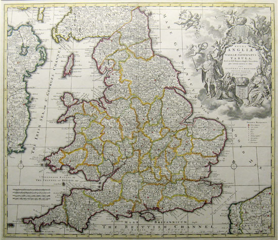
This map shows the countries earlier in the reign of the Hanover Kings, but the elaborate title cartouche celebrates the Glorious Revolution of 1688-89. Britannia sits in the lower right and on the left stands an imposing military figure representing King William. Besides Royal crests and numerous putti, the English lion and Welsh unicorn surmount the impressively engraved cartouche. The map itself is filled with excellent detail of towns, roads, rivers, and with each county colored in a contrasting pastel shade. Covens and Mortier was an Amsterdam firm formed in 1721 by Johannes Covens in partnership with the heirs of Pierre Mortier. Mortier, a Frenchman, had established a publishing house in Amsterdam by around 1685 and published or reissued maps by some of the great French and Dutch mapmakers of the late 17th and early 18th centuries, including Guillaume de L'Isle, Carel Allard and Jan Jansson. After Mortier's death in 1711, the family continued the business and then joined with Covens. Covens and Mortier issued several atlases, including its major work Atlas Nouveau, published in nine folio volumes between 1711 and 1760. The firm also issued world and continent maps. Regni Angliae et Walliae… is variously credited by different sources as being after de L'Isle or Allard. |
| Framing | unmounted |
| Price | £500.00 |
| Stock ID | 10408 |