
| Method | Copper engraved with early hand colour |
| Artist | Homann Heirs |
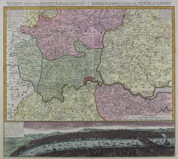
| Published | ex autographo majori Londonensi desumta, Curantibus Homanianis Heredibus 1741 Cum Priv. S. Caes. Maj. [Nuremberg, 1741] |
| Dimensions | 487 x 560 mm |
| Notes |
A large and impressive map of London and surrounding counties, published by the Homann Heirs for the Maior Atlas Superiore. The map is ornamented in full and beautiful hand colour, in Homann's characteristic pink, green, and yellow pastel palette. The city of London is picked out in red at centre, and a key in the top right shows the corresponding symbols for Villages and Hamlets, Windmills, Castles, Stately Homes, Parish Churches, Market Towns, and Towns represented by MPs. The map, as the Homann Heirs state in the German title, is closely based on Thomas Bowles' 'New Correct Map of Thirty Miles Round London.' Likewise, the prospect of London below the map, here entitled 'London u. Westminster von der Sud-Seyte' is a reduced but close copy of John Bowles' prospect. Johann Baptist Homann (20th March 1664 - 1st July 1724) was a German engraver and cartographer, and the Imperial Geographer to the Holy Roman Emperor Charles VI. In 1702 he opened a publishing house in Nuremberg, and his maps often make reference to his membership of the Prussian Royal Academy of Sciences and his imperial patronage. Upon his death, his maps passed to the Homann Heirs company and reprinted many times before the company closed in 1848. Condition: Pressed central vertical fold, as issued. Small tears to top and bottom of central fold. Otherwise an excellent clean example in full and attractive colour. Blank on verso. |
| Framing | mounted |
| Price | £800.00 |
| Stock ID | 47473 |