
| Method | Chromolithograph |
| Artist | Bacon, George Washington |
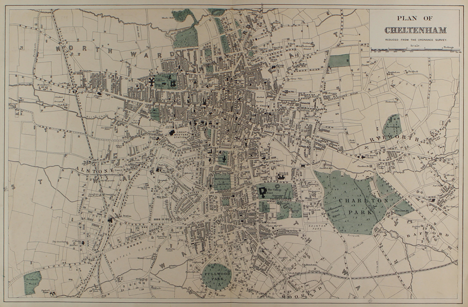
| Published | London, G.W. Bacon & Co. Ltd. 127 Strand [c.1885] |
| Dimensions | 315 x 485 mm |
| Notes |
A detailed late-Victorian map of Cheltenham, by George Washington Bacon. The map is described as being 'Reduced from the Ordnance Survey,' so was most likely printed for Bacon's 'New Large Scale Ordnance Atlas of the British Isles.' The railways are shown as black and white dashed lines, parks and public spaces are printed in green, and the floorplans of buildings are shown, black for public, dashed for private. George Washington Bacon (1830 - 1922) was a prolific London based book and map publisher active in the mid to late 19th century. Bacon was born in New York and emigrated to England c. 1862. He was initially a London agent for the American atlas publisher Joseph Hitchins Colton. By 1871 he had become a British subject and was living in Battersea with his wife and two daughters. He was described on the Census of 1871 as being a map publisher, employing three men, five boys, and one young lady. Bacon died 21 Jan 1922. Bacon's firm G.W. Bacon and Co. produced a wide variety of maps and guides. In 1893, Bacon & Co. acquired the map publishing business of J. Wyld. Then, around the turn of the century, Bacon & Co. itself was folded into the Scottish publishing house of W.& A.K. Johnston. Condition: Central vertical fold, as issued. Minor time toning to edges of sheet. Blank on verso. |
| Framing | unmounted |
| Price | £80.00 |
| Stock ID | 50637 |