
| Method | Copper engraved |
| Artist | Clausner, Jakob Joseph |
| Published | Clausner in Zug Sc. [Barde, Manget & Compagnie, Geneva, 1786] |
| Dimensions | 260 x 295 mm |
| Notes |
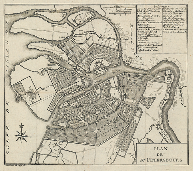
Clausner's detailed late-eighteenth century town plan of St Petersburg, engraved for the French translation of William Coxe's Travels into Poland, Russia, Sweden and Denmark. The original English map, published two years previous in the first printing of Coxe's narrative, was engraved by Thomas Kitchin. The map is centred on the Peter and Paul Fortress and the branches of the Neva River. In the top right corner, a large alphanumerical key provides numerous points of reference for the City's principal buildings and districts. The title is enclosed in a simple box cartouche in the bottom right, and a compass rose ornaments the Gulf of Finland. William Coxe (1748-1828) was an English clergyman, surveyor, historian, and travel writer. Much of his travel writer relates to northern Europe, including Switzerland, Scandinavia, Russia, and Poland, where he travelled as tutor and companion to a number of wealthy British patrons, including Lord Herbert, future Earl of Pembroke, and the brewer and MP, Samuel Whitbread. Jakob Joseph Clausner (1744-1797) was a Swiss engraver, best known for producing copies in French of maps and plates by various British engravers, including Thomas Kitchin. Condition: Vertical and horizontal folds, as issued. Minor time toning and creasing to margins. Blank on verso. |
| Framing | unmounted |
| Price | £275.00 |
| Stock ID | 53449 |