
| Method | Steel engraved with original hand colour |
| Artist | Pigot, James |
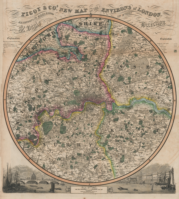
| Published | London. Published by J. Pigot & Co. 59 Fleet St. and Fountain Street Manchester. Engraved on Steel by J. Pigot & Slater, 1839. |
| Dimensions | 465 x 430 mm |
| Notes |
A highly decorative circular distance chart of the environs of London, encompassing parts of Middlesex, Surrey, Kent, Essex, and Hertfordshire, from Pigot's British Atlas. The borders of the counties are outlined in original hand colour, with forests, parks, hills, roads, and railways mapped in detail. Outside the circular border, the remaining spaces are filled with an ornate title and explanatory keys at top, and a vignette of London from the Thames at bottom on either side of a scale of miles flanked by florets. James Pigot (1769-1843) was an English cartographer, engraver, printer, and publisher. He is best known for his series of finely engraved oblong county maps, issued in various National Commercial Directories throughout the 1820s and 1830s, and published collectively as Pigot & Co's British Atlas in 1831. Pigot traded in London with Charles Elkins and Isaac Slater under the names Pigot & Co and Pigot & Slater, while at the same time trading in Manchester in partnership with his son, James Pigot Jnr, under the name Pigot & Son. Condition: Horizontal and vertical folds, as issued. Minor time toning and foxing to margins. Minor offsetting. Chips and small tears to left margin with loss to very edge of explanation. Margin reinstated. Blank on verso. |
| Framing | mounted |
| Price | £550.00 |
| Stock ID | 51562 |