
| Method | Copper engraved with hand colour |
| Artist | Jansson, Jan |
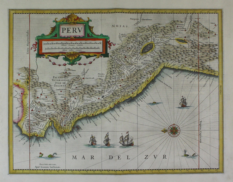
| Published | [Henricus Hondius and Jan Jansson. Amsterdam, 1633] |
| Dimensions | 374 x 484 mm |
| Notes |
A boldly engraved and highly decorative map of the Peru, from the 1633 German edition of the Mercator-Hondius Atlas Major, published by Henricus Hondius and Jan Jansson under the lengthy and descriptive title: 'Atlas: das ist Abbildung der gantzen Welt, mit allen darin begriffenen Laendern und Provintzen: sonderlich von Teutschland, Franckreich, Niderland, Ost und West Indien: mit Beschreibung der selben.' The map is visually rich, and ornamented in superb hand colour. Principal cities are depicted pictorially and highlighted in red, and principal rivers and mountains, as well as sea ships and sea monsters are also depicted. The title is enclosed in a decorative cartouche to the top left corner of the map. Johannes Janssonius (1588 - 1664) was a famed cartographer and print publisher. More commonly known as Jan Jansson, he was born in Arnhem where his father, Jan Janszoon the Elder, was a bookseller and publisher. In 1612 he married the daughter of the cartographer and publisher Jodocus Hondius, and then set up in business in Amsterdam as a book publisher. In 1616 he published his first maps of France and Italy and from then onwards, produced a very large number of maps which went some way to rival those of the Blaeu family, who held a virtual monopoly over the industry. From about 1630 to 1638 he was in partnership with his brother-in-law, Henricus Hondius, issuing further editions of the Mercator/Hondius atlases to which his name was added. On the death of Hondius he took over the business, expanding the atlas still further, until eventually he published an eleven volume Atlas Major on a scale similar to Johannes Blaeu's magnum opus. After Jansson's death, his heirs published a number of maps in the Atlas Contractus of 1666, and, later still, many of the plates of his British maps were acquired by Pieter Schenk and Gerard Valck, who published them again in 1683 as separate maps. Henricus Hondius (1597 - 16th August 1651), often called Hendrik Hondius the Younger to differentiate him from the earlier, and unrelated portrait engraver Hendrik Hondius the Elder, was the son of the famous cartographer Jodocus Hondius. Like his father, Henricus was an engraver, cartographer, and publisher. He first came to prominence through his publication in 1606 of a new version of Mercator's 1569 World Map, the plates for which he had obtained from Mercator's grandson Rumold. Following his father's death, Henricus co-ran the family business, eventually partnering with his brother-in-law, Jan Jansson. Condition: Excellent impression with wide margins. Pressed centre fold as issued. German text on verso. |
| Framing | unmounted |
| Price | £600.00 |
| Stock ID | 42742 |