
| Method | Copper engraved with hand colour |
| Artist | Robert de Vaugondy, Gilles |
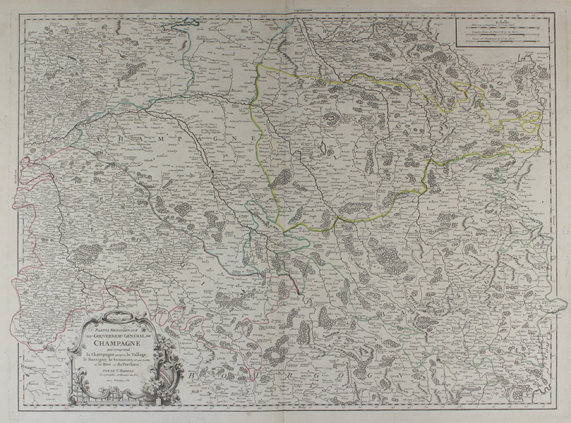
| Published | Par le Sr. Robert Geographe ordinaire du Roi. Avec Privilege 1752. |
| Dimensions | 475 x 650 mm |
| Notes |
A large and impressive French map of the southern half of the former French province of Champagne, outlined in hand colour along with the borders of neighbouring Senonois, Allag, and Bassigny, from Vaugondy's Atlas Universel. The map is exceptionally detailed, with every city, town, village, and hamlet listed, and with forests, mountains, and water courses shown pictorially. In the bottom left corner, the title is enclosed in an ornate baroque cartouche. Gilles Robert de Vaugondy (1688-1766) and his son Didier (1723-1786) were French cartographers, publishers, and globe-makers, responsible for the publication of the Atlas Universel (1757), one of the most significant cartographical achievements of the 18th century. The de Vaugondy family were descendants of the cartographer Nicholas Sanson d'Abbeville, and inherited many of his plates. These were reissued with updated astronomical observations and corrected longitudinal and latitudinal information in the Atlas Universel. Didier continued reissuing the Atlas after his father's death, and was appointed geographer to Louis XV later in life. Gilles often signed his maps simply as Sr. (or Sieur) Robert, whilst Didier usually used 'Robert de Vaugondy' as his signature, occassionally adding 'fils' to clearly distinguish himself from his father. Condition: Central vertical fold as issued. Minor time toning to margins. Small chips, tears, and creases to corner, without loss to map. Blank on verso, excepting a large manuscript '34' in black ink in the top right corner. |
| Framing | unmounted |
| Price | £220.00 |
| Stock ID | 48949 |