
| Method | Copper engraved with hand colour |
| Artist | Bonne, Rigobert |
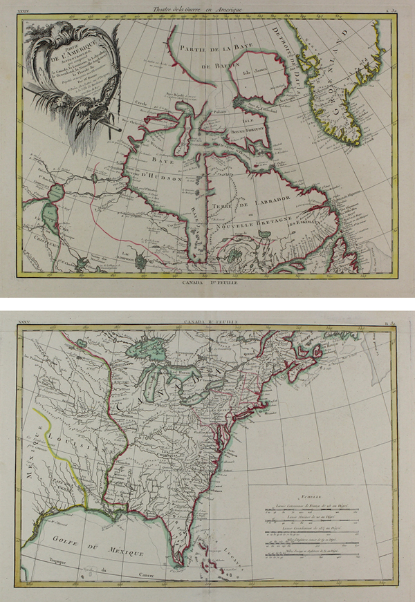
| Published | Projettee et assujettie aux Observations, Par Mr. Bonne. A Paris, chez Lattré, rue St. Jacques, a la Ville de Bordeaux, avec Priv. du Roy, Revue et corrigee 1770. |
| Dimensions | 298 x 430 mm (I.re Feuille), 293 x 430 mm (II.e Feuille) |
| Notes |
A fine pair of eighteenth century French maps of the Eastern Coast of North America, encompassing modern day Canada and the United States, engraved by Bonne for Jean Lattré's Atlas Moderne. The maps stretch from Baffin's Bay to the Gulf of Mexico, presenting the 'Theatre de la Guerre' in the French and Indian War. The map is enhanced by hand colour, with outlined borders for Spanish, French, and British territory. Interestingly, the French regions of Canada, the Lakes, and Quebec are not distinguished at all from the British holdings on the East Coast. A large decorative title cartouche and a scale in French, Canadian, and English miles are also included. A major cartographer of the late 18th century, Rigobert Bonne (1727-1795) was Royal Cartographer to France, succeeding Jacques Nicolas Bellin in the office of the Hydrographer at the Depôt de la Marine. Bonne produced some of the most detailed and precise maps of the period. Bonne's maps represent a departure from the more decorative maps of the previous century, and although much of his cartographic style can be traced to his predecessor, Bellin, Bonne maps are generally less decorative, characteristically lacking ornate cartouches, compass roses, or contemporary hand colour. Condition: Central vertical folds, as issued. Repaired insect damage to bottom of central folds. Blank on versos312. |
| Framing | unmounted |
| Price | £600.00 |
| Stock ID | 48391 |