
| Method | Copper engraved with original hand colour |
| Artist | Robert de Vaugondy, Giles and Robert de Vaugondy, Didier |
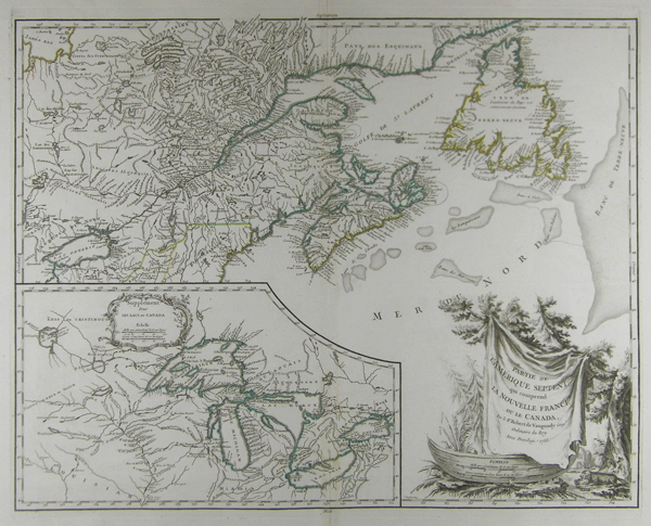
| Published | [Paris c. 1755] |
| Dimensions | 481 x 603 mm |
| Notes |
Influential map illustrating the political situation around the Great Lakes and in Canada early in the American Revolutionary War. The map covers the Gulf of St. Lawrence, St. Lawrence River, and surrounding territories including Newfoundland and Nova Scotia, as well as parts of Quebec, Ontario, New York, Maine, New Hampshire, and Vermont. The inset details the Great Lakes, or as the map defines them 'Les Lacs du Canada.' The map of the Great Lakes roughly follows French cartographer Nicolas Bellin's 1744 map. However this map does extend significantly westward into the lands of the Sioux and the rivers surrounding the Lake of the Woods - no doubt a response to additional French information gleaned from fur traders in the region. Vaugondy's influence on French cartography was significant and this became the standard template for the mapping of this region for roughly fifty years from its original publication. The present example is the 4th state of this map, the last to be issued directly by the Vaugondy Family before the map plates were passed on to Charles Delamarche. This map was originally engraved by Catherine Haussard, one of the few female engravers active in Paris during the eighteenth century. Her fine work extends to the large and elaborate decorative cartouche at the lower right containing the title and scale. The cartouche attempts to illustrate some of the flora and fauna common to the Americas, including a beaver in the lower right corner. Gilles (1688 - 1766) and Didier (c. 1723 - 1786) Robert de Vaugondy were map publishers, engravers, and cartographers active in Paris during the mid-eighteenth century. The father and son team were the inheritors to the important Sanson cartographic firm whose stock supplied much of their initial material. Graduating from Sanson's map's Gilles, and more particularly Didier, began to produce their own substantial corpus of work. The Vaugondy family were well respected for the detail and accuracy of their maps in which they made excellent use of the considerable resources available in eighteenth century Paris to produce the most accurate and fantasy-free maps possible. They compiled each map based upon their own superior geographic knowledge, scholarly research, the journals of contemporary explorers and missionaries, and direct astronomical observation - moreover, unlike many cartographers of this period, they commonly took pains to reference their source material. Nevertheless, even in eighteenth century Paris geographical knowledge was severely limited - especially regarding those unexplored portions of the world, including the poles, the Pacific north-west of America, and the interior of Africa and South America. Condition: Printed on full sheet, with large margins. Central vertical fold, as issued. Some areas of foxing in margins. |
| Framing | unmounted |
| Price | £650.00 |
| Stock ID | 41936 |