
| Method | Copper engraved |
| Artist | Ortelius, Abraham |
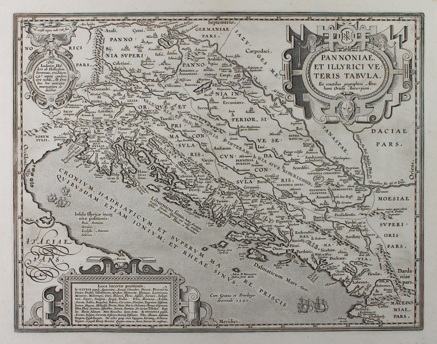
| Published | Ex conatibus geographicis Abrahami Ortelii Antverpiani [Petrus Bertius, c.1618] |
| Dimensions | 358 x 460 mm |
| Notes |
A map of ancient Pannonia and Illyria, roughly corresponding to modern day Slovenia, Croatia, southern Hungary, western Romania, Bosnia and Herzegovina, Serbia, and Montenegro, originally published for the 1590 Parergon (Supplement) of Ortelius' famous Theatrum Orbis Terrarum. This particular example is unusual in having no verso text. The map is likely either one of a number of Ortelius' ancient world maps sold to Petrus Bertius for inclusion in his Theatrum Geographiae Veteris, or similarly a single issue sold by Vrients for inclusion in an extra-illustrated book or composite atlas. The map depicts the ancient kingdoms, tribes, and peoples of the region, as well as Greek settlements in Liburnia and Dalmatia, and the later Roman provinces and regiones of Noricum, Forum Julii, Pannonia Superior and Inferior, Germania Inferior, Dacia, and Moesia. Despite listing the names of the subdivisions of Pannonia under Diocletian (Valeria and Secunda), the map does not feature his famous palace at Spalato (modern Split), with Salona taking precedence instead, probably because of its role as the original Roman capital of Dalmatia and birthplace of Diocletian. In the waters of the Adriatic groups of sailing ships ply their trade, potentially a reference to the piracy for which the region was notorious before its subjection to Imperial rule. The map is further ornamented by three strap-work cartouches. The largest of the three, in the top right, encloses the title and features the chi-rho monogram at top and a horned and goat-faced satyr mask below. A medallion in the top left contains a dedication to Ortelius' friend Ludovicus Hallerus, likely a scion of the Hungarian branch of the influential patrician family of Haller von Hallerstein. The third cartouche, in the bottom left, contains a list of places of uncertain location. The Parergon ('Supplement') was, as the title suggests, originally conceived of as a supplement to Ortelius' Theatrum. The work, a massive and intricately researched index of the classical world, was accompanied by a series of ancient world maps. Unlike the maps of the Theatrum, the majority of which were reductions of earlier maps, the maps of the Parergon were researched and drawn by Ortelius himself. The work was a huge commercial success, and the maps themselves set the standard for ancient world maps for the duration of the seventeenth century, being reproduced or reprinted by various publishers after Ortelius' final 1624 printing. His interest in the mapping of the ancient world is manifest. The maps of the Parergon are a veritable mine of textual commentary and classical philology, drawing upon Ptolemy, Strabo, Pliny, and many others. Interestingly, the project seems to have been a labour of love, rather than a mercantile venture. Ortelius himself was fascinated with the ancient world, and a formidable classical scholar in his own right. In addition to his work as a cartographer, he dealt in antiquities, visited and surveyed ancient sites across Europe, published a critical edition of Caesar's Gallic Wars in 1593, and assisted Welser in his studies of the famous Tabula Peutingeriana in 1598, producing an engraved copy of the map that can be found in later editions of the Parergon. Abraham Ortelius (1527 -1598) was a Flemish cartographer, cosmographer, geographer and publisher and a contemporary of Gerard Mercator, with whom he travelled through Italy and France. Although it is Mercator who first used the word "Atlas" as a name for a collection of maps, it is Ortelius who is remembered as the creator of the first modern atlas. Theatrum Orbis Terrarum was the first systematically collated set of maps by different map makers in a uniform format. Three Latin editions as well as a Dutch, French and German edition of Theatrum Orbis Terrarum were published by 1572 and a further 25 editions printed before Ortelius' death in 1598. Several more were subsequently printed until around 1612. Ortelius is said to have been the first person to pose the question of the continents once being a single land mass before separating into their current positions. Ex.Col.: László Gróf Condition: Clean, crisp impression with full margins. Central vertical fold. Minor time toning to fold. Waterstain to top right corner of sheet, not affecting map. Blank on verso. |
| Framing | unmounted |
| Price | £600.00 |
| Stock ID | 51016 |